Shahid Saeed
Automotive Navigation Systems have become extremely popular all over the world in today’s world. They are used extensively in major cities around the globe; by everyday people, by taxi drivers and by the general public of the city. The bigger the city, the more the need for a navigation system.
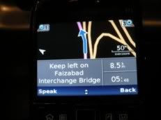
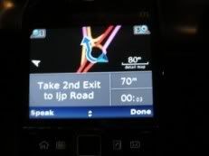
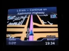
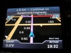
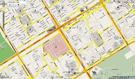
The images above show directions in the Rawalpindi-Islamabad twin cities area – more detail below
Sadly, we Pakistanis have long been deprived of this technology but finally we have working SatNav in Pakistan. Improper urban planning, lack of technical infrastructure and lack of voluntary efforts are the three main reasons SatNav has remained ineffective for Pakistan. While major companies are not keen in investing here keeping in mind the not so high revenue they would generate, the people have themselves not created maps for themselves because they want everything for free.
The biggest player in satellite navigation today, Garmin and TomTom have not developed any maps for Pakistan. They don’t see a reason why they should do so. But they have been gracious enough to provide software (and people have developed even better ones) to create maps capable of running on their GPS devices. A bunch of volunteers have dedicated quite a long time in creating maps for many cities of Pakistan and I’ll be explaining the extent to which these maps are effective later on.
Free Online Maps:
The two biggest names in community created online free for all maps are OpenStreetMap and Google MapMaker. The main difference between the two is that OpenStreetMap provides its map data under a Creative Commons license, any maps created by users of Google Map Maker are the intellectual property of Google. Both are community created and with time, they have developed quite detail. For cities like Islamabad and Karachi, they present a very high detail and therefore are a success for the online community. Google has promised that with time it will verify the integrity of the created maps and then export them to Google Maps.
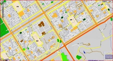
A comparison between the two (location: PIMS – Jinnah Avenue Interchange, Islamabad) can be seen below :
Google Map Maker:
Open Street Map:

The level of detail as seen in the above pictures is quite satisfactory for pre-departure route planning.
Naqsha.net:
This was Pakistan’s first interactive map website. They provide two different online versions of their maps. One uses overlayed layers on Google Maps while the interactive maps utilize Adobe SVG Viewer to provide very good street level maps of all major cities of the country. The interactive maps also allow a user to plan a route quite easily. The same intersection is shown in Naqsha.net’s hybrid viewer below :
The best thing is that they provide excellent routing capabilities. The fastest or shortest distance calculations it does are indeed the ones which anybody could easily use.
Naqsha.net also provides maps for Garmin devices, and many people have utilized their maps.
Garmin Maps (Provided by http://pkmaps.freeforums.org/)
A bunch of what I can assume are GPS enthusiasts have worked hard to develop these Garmin compatible maps. Using free software available over the Internet, they have worked tirelessly to create maps for Islamabad, Lahore, Karachi, Peshawar and Wah Cantt. Indexed (means address searchable) versions are also available. The forum encourages open source map creation and does not allow discussion about cracking/unlocking premium maps available for the region.
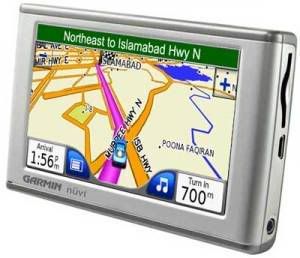
Using maps provided by this community, I have been able to install a perfectly working Garmin Mobile XT. The GPS chip in my Nokia E71 is of course not the greatest, and I am able to lock my location in a minimum of 13m radius.
A-GPS (Assisted GPS), which primarily works by locating your position roughly by comparing your cell site on the cellular network to an existing databese of these cells/towers and thus triangulate you, is of course of hardly any use. The maps developed by these chaps provide a very good detail and make navigation for an unfamiliar person at least easy (of course the address in hand would be 3rd house on the right, after the second turn under the Pine Tree).
The setup demonstrated below is by using a Nokia E71 and Garmin Mobile XT. Garmin’s software was of course cracked using a keygen, but the maps provided by pkmaps are free to distribute. The onboard GPS has provided me continuously with even 8m lock.
As a demonstration, I want to bring to attention the title photos of this post above. These pictures show a drive from my home in Rawalpindi to Jinnah Super Market in Islamabad. The maps were of course not up to date, but will provide a relief to somebody new in the city. I am working on improving the Rawalpindi section of the twin city maps, and with even more volunteers we can create a very detailed navigation map.
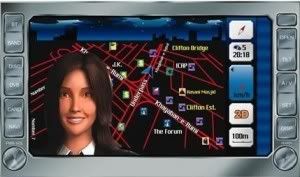
Naqsha.net has teamed up with Tracking world to provide Garmin SatNav units preloaded with maps. In-car GPS navigation is not available in Pakistan. The unit provides a range from in-car dash mounted devices to devices for motorbikes.
 There is also a unit which can be integrated with the vehicle’s DVD/entertainment unit and displays the navigational information on it. Existing Garmin users also have the option to buy the map for their specific unit.
The map has street level detail of major Pakistani cities and all major national highways. Streets are labeled and searchable for Islamabad, Lahore and some parts of Karachi.
In addition there are close to 40,000 POIs such as fuel/CNG stations, banks, ATMs, hospitals, restaurants (categorised), hotels, shops, etc. Most POIs have address and phone number information available as well. Units equipped with FM transmitters and Bluetooth allow hands free dialing from the unit and are able to integrate with the vehicles’s audio system as well.
The current base unit, Garmin Nuvi 200w, retails for Rs. 29,750. If you are in Lahore, visit the display centre at Tracking World (Pvt) Ltd. For people in Islamabad units are on display at Hi Volts (F-8 Markaz) and Illusions (F-7 Markaz). You may also call at 042-111-22-66-66 for details.
Like Naqsha.net they also claim to be the first to introduce SatNav in Pakistan.
 Trakker Group provides car tracking for personal or commercial use. They stepped into sat nav couple of years back.
The in car SatNav provided by Trakker has extensive maps for Karachi District. The very small number of customers who have used their service are extremely satisfied with their product as it has very good routing capabilities. The limitation remains the maps being for Karachi only as of now. The system provided with them has DVD playback and other benefits as well but is very costly.
Note: Versions of this post have also appeared here and here.
ATP’s Other Posts:
RFID Based E-toll System introduced on Pakistan Motorway


Rent a Car Islamabad Airport has gotten capable resources i.e. experienced work, latest model of automobiles, open business regions, and master working relations with the partners in the movement business, for instance, well known hotel systems, obvious flying transports, and best visit overseers to get the most engaged rates and lucrative organization can foresee the customers. Islamabad Rent a Car Why you should pay for the additional space that will be un-used for when in doubt. Lease an auto bunches put forward best rental auto benefits in Islamabad that join both sensible rates and quality association.
Dear ALL,
Trakker have launched another application for IPhone, I pad and android phones.
We have also re-launched IN CAR NAVIGATION…
Features of our Product:
1) User friendly software
2) Advanced Search System
3) Optimal Route Calculation
4) House Address / POI search
5) Turn by Turn voice guidance
6) Coverage of 89 cities.
7) 365,849 House Addresses.
8) 81,000 POIs
9) Including 3D landmarks/POIs
See LINKS: http://itunes.apple.com/pk/app/sygic-pakistan-gps- navigation/id447065901?mt=8
if i want to purchase this whole system to be installed in an ordinary taxi how much would it cost per taxi??
for free mobile navigation software visit the link below
http://mobile-navigator.blogspot.com/
Dear Sir ,
This is to inform you that i want to install Mobile Booster/Mobile Tower /Wireless Tower. I have a Building 150 sq yards In khosar Hyderabad and i want to install a Mobile Booster/Mobile Tower /Wireless Tower at my building roof at reasonable rent. There was no signal of any network. This is most suitable location for your Mobile/Wireless Booster installation. If you have any chance to implant the Booster of Mobilink, Ufone, Telenor, Warid, Zong, V Wireless, I provide my building’s roof for installation of your tower for a reasonable rent for smooth functioning of your Network.
Kindly send your Survey Team for inspection and give me a chance to be apart of your business. Your Co-operation will highly appreciate.
Name; Mohammad Nawaz
Contacts : 0322 3111549
Email : nawazhyd@yahoo.com