This is one topic I’ve been wanting to write about for a while now. But instead of me writing on it, we want to do an experiment here. We would like our readers to tell us what do they know about the project. I will then compile the information collected from your replies here and I am sure in few days we’ll have a treasure of knowledge on this project. This will test the power of our little blogistan where everyone contributes. Your participation is a key here. Try to send authentic information – suni sunaai pe naa jaaeN. The idea is that overtime this post will grow into a information storehouse on Lahore Ring Road Project.
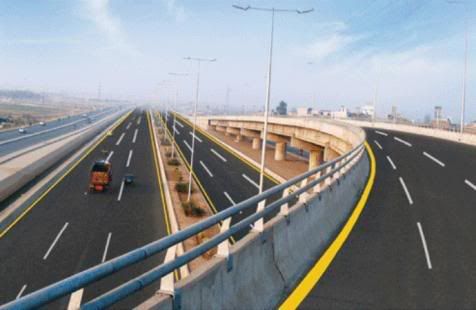
Following photo of a completed interchange on LRR appeared in print media on February 2, 2010.
I will also chip in with whatever information I can research. If you live in Lahore, you can share your experience about ongoing construction. You can send links to project maps, construction photos, tell us about portions that have been completed, any story about people who got affected by the project’s right-of-way, environmental impact of the project, politics (if any) about the project etc.
OK lets start and see this post grow. What do you have to say? Anything below this paragrpah will be yours and mine contribution. You can communicate via comments.
—
Project Chronology
1983-84: The Lahore Ring Road project was first conceived around this time as a bypass to Lahore city and ease congestion on inner city roads. It is unclear that who came up with the idea of this project but it was around this time that the project made news in media.
1991:JICA, an institution of Japan, proposed a road-loop in the city and the World Bank prepared a feasibility report on a 60 km ring road around the city.
1992: Changes made to the initial JICA/World Bank design. Details of changes unknown. Readers’ help needed.
1995: This circumference of LRR later increased to 77 km when Lahore Development Authority (LDA) included Raiwind road in the design.
1997:The feasibility of LRR design made by Lahore Development Authority got finalized.
1999: Changes are made to project design. Details unknown.
December 22, 2004: Pervaiz Musharaf, the then President of Pakistan performs the ground breaking ceremony of the project.
2007: Changes are made to the design fourth time. Details unknown.
December 2007: Government of the Punjab awards the project’s Southern Loop Feasibility Study and Selection of Route to NESPAK.
December 31, 2008: This was the original date set for project completion when it started on December 22, 2004
July 30, 2009: Mian Muhammad Shahbaz Sharif, the Punjab Chief Minister, inaugurates the Saggian Interchange of Lahore Ring Road. The Saggian interchange includes 1.08 km long portion of the main Ring Road, 2.12 km outfall road, a flyover, two subways and two utility culverts. The project also includes landscaping, development of service areas and bus-bays.
August 6, 2009: Work started on Package 6 and 7. The length of ring road in this section is 4.5 km with 1.8 km long access to Allama Iqbal International Airport.
September 7, 2009: A public hearing was held for the Lahore Ring Road Packages 10, 15, 16 and 17 at Alhamra Cultural Complex. The presentation was made by Engineer Jawad Ahmad Khan and Sociologist Sheraz Hussain of NESPAK. Various officials from the Environment Protection Department and Communication and Works Department, Government of the Punjab attended the presentation along with stakeholders.
October 26, 2009: Punjab Chief Minister, Shahbaz Sharif met with a delegation of China State Construction & Engineering Company led by its Vice-President of Overseas Department Mr Wang Li. Possible cooperation from the Chinese company was discussed for the Lahore Ring Road Project.
February 10, 2010: Package 6 of Lahore Ring Road is inaugurated.
Project Cost:
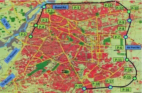
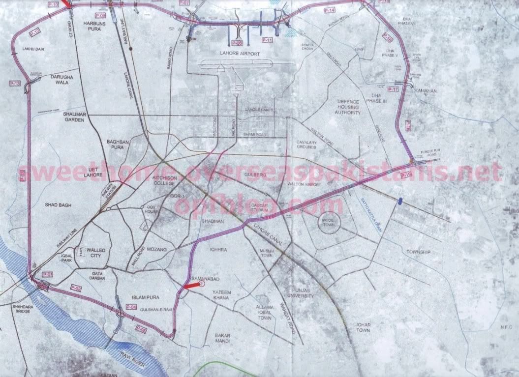
NESPAK website lists the cost of 19 packages of Lahore Ring Road Project (as shown in NLC map 3 below) as USD359 million.
Project Maps:
Please click on the maps below to see their larger and better readable images.
(1) Current Project Map Following map comes from National Logistics Cell (NLC)’s website and the consensus is that this is the current and most accurate map of the project.
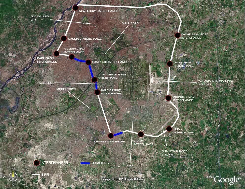
(2) Google Earth map. Taken from SkyscraperCity page here.
(3) Older Map Following map comes from NESPAK’s website.
We want to caution readers that this is not the latest plan. Shown here as part of history of the project so that we get to know what all other plans were made for the project.
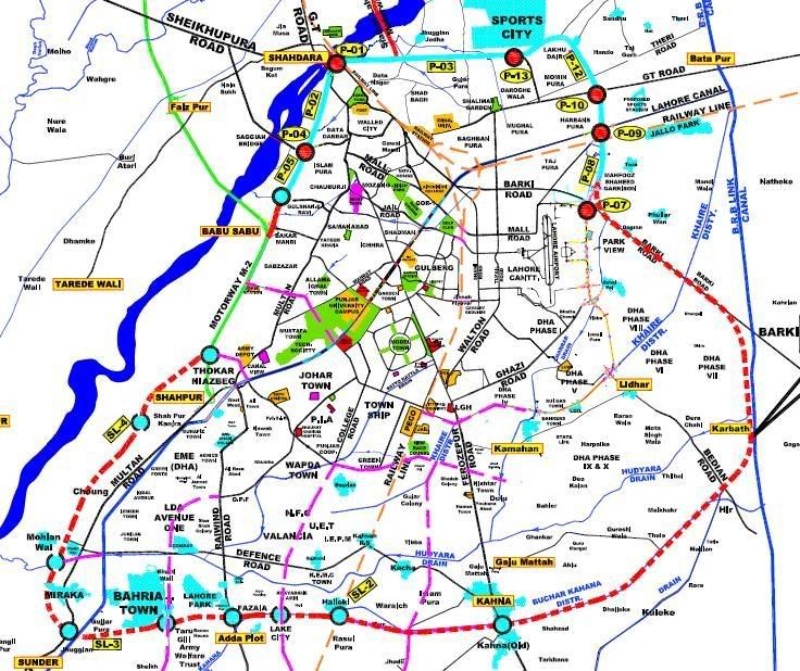
(4) Older Map This is the map of the project from an earlier plan. We are grateful to our reader ‘momers’ who guided me to this map. This map seems to have come from print media and is probably the most commonly found map of LRR on the web. Another contrbutor ‘Strong Hearted’ says about this map that this was an earlier plan. The ring road will not pass from the middle of the city as shown in the map below.
Useful Photo Links to the Project:
1. SkyScraperCity :Several Photos of LRR during its constuction phase – dated 2009-2010
2. One more page at Skyscrapercity on Lahore Ring Road Project and several other Lahore projects.
3. Urbanpk Forum: Has news, maps and discussion about Lahore Ring Road Project.
4. Lahore Ring Road photos at photobucket
5. Someone with the screen name of ‘lakar mandi’ has collected several photos of under construction LRR and shown them as a slide set on youtube. see below:
References:
1. Lahore Ring Road, a distant dream? by Wasim-ur-Rehman Khan
2. National Engineering Services Pakistan, Ltd (NESPAK)
3. National Logistics Cell (NLC)
4. Lahore Master Plan map by Lahore Real Estate – This is not a map by an official agency but it shows the alignment of Lahore Ring Road pretty well.
5. Shahbaz Inaugurates Package VI of Lahore Ring Road
6. Ring Road Plan Modified – Length Shortened – Dawn September 7, 2005


Great to see momentum building on the discussion here.
@Strong Hearted. I’ve shuffled the maps according to your advice and have put the caption of ‘Current Map’ on NLC project map and ‘older maps’ on map 3 and 4.
I don’t want to remove older maps as together do form a history of the project and a one-place-stop where readers can see how the project evolved to its present map.
for having a best idea about the design of LRR plz visit this link
http://www.lahoreestate.org/le-map/lahore-master-p lan-map.html
@ Momers
sir u have posted such a long comment that it would be difficult to clear ur all confusions:) but let me try somethings that i can clarify u!
ur first three paragraphs have a simple answer
“YES! the plan was just ridiculous to pass the ring road through the center of the city. but this govt cancelled all such plans and now the final plan is to construct a proper ring road around the city.as i said in my earlier comment that its the southern loop that will complete the ring around the city.and its plan and design work is complete and construction starts in next fiscal year”
the portion that is complete/under construction uptill now is that which is shown in second pic (NLC pic) .thats the exact design of current ring road underconstruction. and inshallah it will be completed in next 1 year with the pace with which work is currently going on!
secondly u asked that first map differs from second. i already said in earlier comment that first map has some ridiculous mistakes so dont go for it. second map is the best one out of all
“I REQUEST THE AUTHOR OF THIS POST TO PLZ REMOVE ALL THOSE MAPS EXCEPT THE SECOND MAP BECAUSE ITS CREATING CONFUSION IN THE MIND OF READERS.ITS ONLY THE SECOND MAP THAT IS CORRECT AND ACCURATE”
Southern loop will start from P-19 and end at thokar niaz beg itnerchange and its the part of the Ring road
So I had been saving this discussion but it got jump started!
Taking the Ring road THROUGH the city via Ferozepur road was/is a ridiculous idea! (Map 4 above). And the fact whether it is still part of the ring road or not is something i would like more clarity on as well as absolute certainty.
But what a stupid idea to begin with. Ring road ought to bypass the congestion of the city and take the load off the city streets and then you go ahead and put the ring smack in the middle of the city. Not to mention that such a design would have ignored the other half of the city namely model town, johar town etc, all the localities to the west of ferozepur road, basically you never took off traffic from the inner roads of these localities!
Another criminal aspect, the bisection of Gulshan Ravi locality. With the Map 4 design the ring was (is?) to pass right through the heart of Gulshan Ravi! What a nightmare for the people living on the periphery Much hue and cry was raised about this in the papers and I had bookmarks of local newspapers, pages which have now been taken off. But the question remains, will the ring road in any form or way pass THROUGH Gulshan Ravi?
For the residents sake i certainly hope it doesn’t, ever!
I personally would vouch for the NESPAK Map 1 above as being closest to reality since to me it is the most recent (June 2009) when NESPAK invited a tender for certain materials. But this map differs significantly from the other NLC Map which is a surprise.
This poses theoretical questions. Is the Southern Loop a new ring road such that the Northern Loop and Southern over lap to some extent?
The NESPAK map due to its Southern Loop and the NLC map due to its listed packages and a close scrutiny of the maps suggest that these are ‘two independent roads’ such that they have the Burki Interchange (P-7) in common (next to the airport).
So at the Burki interchange (P-7), Northern loop (original ring road) heads south (on to packages P-6, 11, 14, 15, 16, 17, 18 , 19) while the Southern Loop heads south-east and scribes a bigger ring around the expanding city of Lahore?
Is so, then the original northern loop ends at ferozepur road close to Chungi Amar Sidhu and basically has an unconnected open end!?? Given that ferozepur road is no longer part of the ring road?!
Zooming in on the original NESPAK .pdf from where this Map 1 was sourced (google NESPAK LAHORE RING ROAD), it becomes clear that the above case might be true as there are some markings showing/suggesting the locations of Packages 17 18 and 19 and hence these packages are not a part of the Southern Loop, and hence my claim of a dangling open end and two independent roads.
What do the others think?
@Naeem Ahmed Bajwa!
Only 1 plan in all those pics is somewht accurate. the plan shown in second pic of NLC. the plan shown in first pic is just ridiculous .
the work on southern loop of ring road will start in next fiscal year. southern loop starts from ferozpur road interchange and ends at thokar niaz beg interchange. the design and plan work of this interchange is complete .
and yes this information is from the authenticated source that after completion the Ring road will be a limited access road!