Attock District in Punjab, Pakistan, is a place of great historic significance. Alexander the Great of Macedonia passed through it as did the first Mughal, Babar, and the various Afghan Sultans before him.
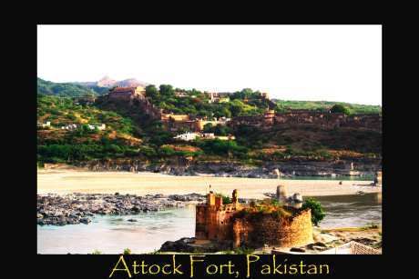
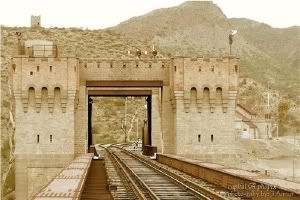
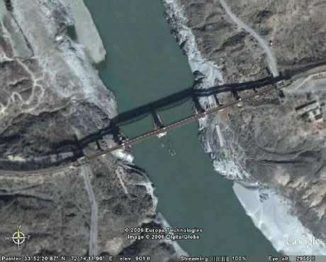
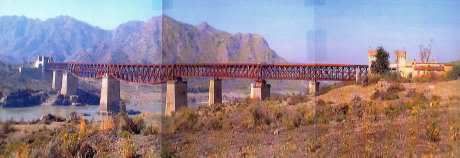
Emperor Akbar the Great, the grandson of Babar, recognizing the strategic importance of this area in 1581 built his famous Attock Fort complex here. The fall of Mughal Empire in eighteenth century saw the rise of Sikhs in Punjab and Durrani Afghans to the west. Once again Attock became a battle ground between two contending powers. British finally ended the feud by subjugating both Sikhs and Afghans in the nineteenth century. British at the same time also brought rail line to the area, built first permanent bridge in 1880 over the Indus River, and established a new city of Campbellpur. After independence of Pakistan the city was renamed as Attock City while the old city by the river is called Attock Khurd (Little Attock).So what gives Attock its historic significance and strategic importance?
The answer lies in geography. Located at the rim of the Potohar Plateau and overlooking the Kabul-Indus River confluence to the north, Attock is the historic gateway to the Central Asia.
 Mr. Jawahar Lal Nehru, the first Prime Minister of India is known to have said: “As soon as I cross the Attock Bridge across the Indus River I feel as if I am in Central Asia�.
Indeed Attock is the eastern terminus of the Kabul-Attock corridor to the Central Asia through which for centuries have passed the armies and the caravans alike. However unlike the modern highways, this corridor is not a work of engineering marvel but an act of nature as it was naturally carved through the Hindu Kush Mountains by the legendry Kabul River and its numerous tributary rivers and streams. Traveling through the historic Kabul-Attock corridor and its adjoining valleys is in essence following the journey of the Kabul River and its tributaries.
The 435 miles long journey of River Kabul starts just west of the Kabul city in Afghanistan and ends at Attock where it ultimately falls into the River Indus. The river rises in the Sanglakh Range 45 miles west of the Kabul city as a small trickling and flows east towards Jalalabad and ultimately into Pakistan. Half mile east of Kabul city it is joined by the River Logar from the south and then about 40 miles below the Kabul city joins the River Panjshir flowing down from the north. On its way to Jalalabad, Kabul River is also joined by smaller rivers like Tagao, Alingar/Alishang combined, and Surkhab. Then about two or three miles below the city of Jalalabad it is joined by the Kunar River, which first rises in Chiantar glacier in Chitral, Pakistan as River Mastuj and flows southwest into Afghanistan.
 Once in Afghanistan the Kunar River gets joined by Bashgal River from Nurestan before it finally merges with Kabul River. Kunar River brings in enough waters from Chitral and Nurestan areas that a few miles below its confluence with Kabul River a hydroelectric plant is built to harness river energies. This is the first water works on River Kabul.From Jalalabad onward River Kabul cuts deep gorges through the Mahmond Hills, curves northward and approximately forms the international border between Afghanistan and Pakistan for several miles and then turns eastward again to be completely inside Pakistan just north of the legendry Khyber Pass. Ultimately in a perfect inverted U shape the river heads south towards the plains of Peshawar, the capital city of the Frontier Province of Pakistan.
Now this is the route through the Kabul River Valley, that armies of Alexander the Great and other invaders from Central Asia after him took to reach down to the plains of Peshawar.
 These days, since 1945, the Upper Kabul River Valley in Afghanistan is occupied by the modern Kabul-Jalalabad-Peshawar Highway. However the highway does not completely follow the ancient route and instead, from Jalalabad onward it zigzags over the mountains and reaches Peshawar via Torkham and Landi Kotal through the legendry Khyber Pass. There is not much vehicle traffic through the river gorge; however the river itself is navigable by flat bottom boats or rafts and is considerably used for two-way commerce between Afghanistan and Pakistan. The gorge is narrow and deep and could easily lend itself as a site for a hydroelectric project but unfortunately neither one of the two countries has considered any such project yet.
In Pakistan the first head works on Kabul River is the Warsak Dam placed near Michni Fort. From this point various canals are developed in order to irrigate Peshawar Valley; these canals have significantly contributed towards the prosperity of the Charsadda district. Bara River flowing in from the Khyber Agency in the southwest is the first tributary to the Kabul River in Pakistan. These days Kabul River Canal originating from the Warsak Dam, after joining with Bara River provides waters to the Peshawar area and then travels further east to ultimately fall back into the Kabul River near the city of Nowshera.
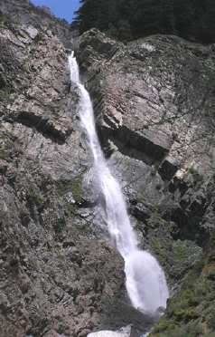
 Another and a major contributor to the Kabul River in Pakistan is the Swat River. It rises in the northern Swat near the city of Kalam and after traveling southward for about 70 miles gets joined by the Panjkora River near the town of Kalan Gai in Malakand District. The Panjkora River itself, just like Swat River, rises near Shiren gai in Dir and travels south to meet its counterpart. Together these two rivers continue to travel southward as Swat River and after passing through the Mahmond Agency fall into the Kabul River near Charsadda. The total length of Swat River is about 140 miles. Saidu Sharif is the most important and a capital city along the banks of River Swat. In the historic times these river routes were used both in war and peace. However with the opening of Jalalabad-Peshawar Highway and the Karakarom Highway to the further east, these ancient river routes even though now equipped with modern highways have lost their international significance and presently are used for the local traffic only.
British by 1895 under the leadership of Sir Robert Low had subjugated the Yousafzai clan of Swat, established a fort near the Malakand Pass and then brought rail line from Nowshera to Dar gai. They had also connected Swat with Malakand by tunnels thus further minimizing the importance of the ancient route via Swat River. Not only that, the Swat River itself was partially diverted at Malakand hydroelectric project as some of the river waters are forced to go through three mile long man made tunnels to a fall of 350 feet.
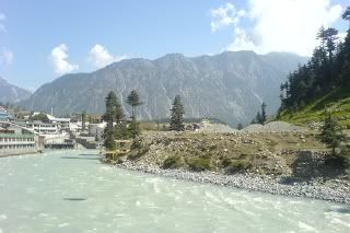 At present there are two power houses at Malakand Khas and Dar gai respectively and a third one is in the planning. At the bottom end of the tunnels the river waters are channeled through the Upper and the Lower Swat Canals. The Lower Swat Canal after passing through Mardan and Rasalpur areas falls into Kabul River near Nowshera. The Upper Swat Canal falls into the Kabul River just above the town of Jahangira named after Emperor Jahangir, the only son of Emperor Akbar. Jahangira is located on the right bank of the Indus River at its confluence with River Kabul. The rail line and the famous Grand Trunk, commonly known as G. T. Road, from Nowshera to Attock travels through the Lower Kabul River Valley along the banks of the River Kabul.
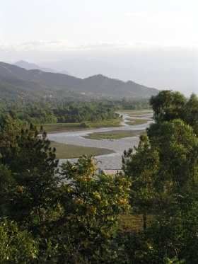
The journey of the Kabul River that starts from the Sanglakh Hills just west of the Kabul city in Afghanistan finally ends at the Indus River just north of Attock in Pakistan. The confluence area is a known sanctuary for the migratory birds flying between Siberia and Indus River delta in southern Pakistan along the Arabian Sea. The total run of the Kabul River and its tributary rivers adds up to be more than one thousand miles. All together from seven to ten significant tributary rivers and their picturesque valleys belong to the overall Kabul River system.
The thousands of square mile area of the Kabul River watershed, which is separate from the Upper Indus River watershed in Northern Areas of Pakistan, is stretched from Gazna to Panjshir Valley in northeast Afghanistan and from Khyber Agency to Chitral, Dir and Swat in northwest Pakistan. Today even though the ancient river routes of the Kabul River tributaries have lost their original significance, the new potentials for commerce, tourism industry and the river water developments are considerably significant. In the best interest of their people, the governments of neighboring Afghanistan and Pakistan need to minimize their political differences and cooperate mutually to fully realize the potentials of their joint Kabul River system stretched from Gazna to Kalam and from Kabul city to Attock City.
Pervaiz Munir Alvi is a Ravian and trained as a Civil and Geo-technical Engineer. The factual information for this essay was obtained through a research of multiple existing sources.


Around 1936, I used to live in Khairabad Kund where my father was posted as the station master at the railway station. This station was housed in a fort being very close to Wazirstan. We used to travel to Cambpalpur for provisions and Nowshera for medical needs. Khairabad Kund had a primary school where studies were in Pashto language.
Attock fort was a very impressive historical monument and I visited this as a child. Attock railway bridge was also an attractive site. Indus river was very wide and fast flowing river.
GT road and the railway line from Rawalpind to Peshawar were running alongside each other with important stations such as Taxila ( museum), Wah ( known for a cement factory), Hasan Abdal ( very famour for Panja Sahib Gurudwara), Attock, Nowshera ( a large cantonment).
Over seventy years later I still remenber these places very well as they made deep impression of peaceful living.
God help Pakistan. In such a perilous time and a new world created by likes of George W. the only hope is to pray and pray hard.
Great Idea at Spam protection.
I also salute and thank you for allowing my posts to be still there. Thanks for this manifestation of the right of all to put their view across. In the same vein I wish to quote from a post that mentions Panini and Atak (Attock).
Find the rest of the article here:
http://rand-rambler.blogspot.com/2006/08/panini-gr ammarian-par-excellence.html
Historically, pANini was born in Attock in today’s Pakistan in the 6th century BCE. Just a brief digression about his birth and its place. Attock is a place close to Peshawar, which is the capital of the now lawless North Western Frontier Province, where Osama bin Laden is supposed to be hiding now. Recently there was an interesting program on television which showed the lawless trigger happy folk of the NWFP. I could not help but think that around a couple of thousand years ago, even these people would have been cultural sanAtana dharmIyas. Looking at how notorious this place has become on the world map, it made me cringe when I realized that pANini was also born around the same place. Does the Pakistan government even realize that such great people walked its soil before the RoP (I am sorry that I have to give such a link) wrought havoc in the area? Do the people in that area even realize that their ancestors were the likes of pANini? Or is the official position that they were all supposed to be in jahiliyya? Anyway, let me get back to pANini’s wonderful grammar.
Hello Guys,
I’m Aditya, an aspirant Script writer. Nowadays I’m writing a script for Theatre which is all about Peshawari Pathans & Khan Abdul Gaffar Khan. For that purpose I need a little help from You people. I need some details about the famous ‘Qissa Kahani Bazar’ & Pashtun ethos as well as basic conversational sentences of the famous Hindko Language.
will any body care to help me ? Please do the needful.
Thanks.
good photograph of attock fort
Maratha’s peshwa also Ruled Attock for
atleast for 4-5 years althe way from western India