 The landscape of Sindh Province is mostly associated with deserts as well as agricultural and coastal table lands. Sindh however is endowed with much more than that. Few days ago we introduced the highest place in Sindh reachable by road called Gorakh – where it snows in winter – and today we’ll introduce another road less traveled in Sindh. It is called the Toshangi gorge and it is located in Kirthar Range of mountains on Sindh-Balochistan border. The word Kirthar in Sindhi means ‘milk-cream’ which is a bit luxurious name for the harsh environment here.
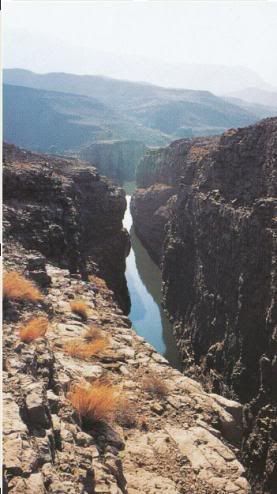
A British archaeologist, author and civil servant named Hugh Trevor Lambrick, who was the Deputy Commissioner of Larkana in 1940s, called Toshangi the Grand Canyon of Sindh. It is one of the most dramatic places to visit in the Kirthars. The deep gorge (700ft deep) is formed by the waters of Kenjhi River which has been flowing in the area since time untold.
How to Get There:
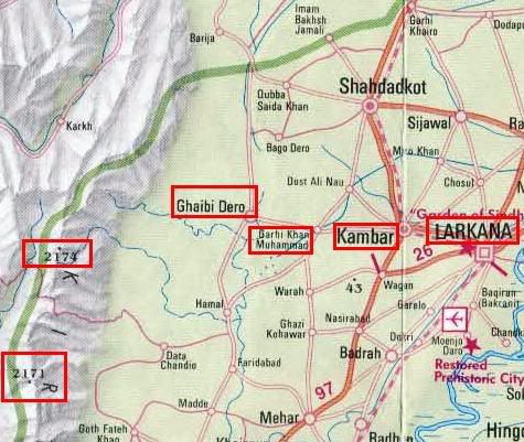
Toshangi is reached from Larkana. From Larkana a road goes westwards to the town of Kambar and then further to the village of Garhi Khan Muhammad and the last stop on this paved road is the town of Ghaibi Dero. Ghaibi Dero is 64 km (39.3 miles) from Larkana. Ghaibi Dero is famous because it is the seat of famous and powerful Chandio family. Ghaibi Dero also lies at the head of the Khenji River. From here a jeep track follows Khenji River westwards for an hour’s jeep journey (other choice is to travel by camel) until it reaches a village called “Rahu jo Aitho” (exact distance unknown to me). This little village is the starting point of Toshangi gorge.
No Jeep After This Point:
Toshangi gorge is best explored on foot. The place is so untouched from commercial touris that there are not even jeep tracks here. From Rahu jo Aitho village, it is a full day’s trek along the river to see and admire the complete Toshangi gorge. A tourist guide of the area says:
It is a good one day’s trek along the river through some truly spectacular scenery, with stark ridges of dark and light-colored limestones and shales rising precipitously to razor-edge crests, sandy stretches and gravel wastes, deep ponds of liquid emerald and tiny oasis of trees, Persian wheels and cultivation that mark rare villages.
Toshangi gorge then reaches a point called ‘Lohiro’ from where Khenji river turns northwards and within few hundred meters from here lies the main Kirthar ridge with a giant crack stretching all the way up to the 1500 m (5000 ft) high peak of Machhal. It is through this deep and narrow cleft that Khenji rivers makes a head start and causes flash floods during rains. There is a local legend that a giant cauldron brimming with treasure hangs at the head of the Khenji cleft.
The two banks of Toshangi gorge run as high as 200m (700ft) above the surface of calm river Khenji.
Who Lives in Kirthars:
The jagged Kirthars stretch along the Sindh-Balochistan border and form the de-facto provincial boundary. The range is inhabited by Brahuis on both sides. Chuttas of Balochistan, Chandios and Gainchos of Sindh also live in this area.
Is It Safe to Travel:
May be not at all times. There are usual bursts of peace and ‘dakoo raj’ intermingled with eachother. It is said that one should go through Chandio family at Ghaibi Dero to arrange for the travel through this area. Our idea of introducing this place here is to highlight the beautiful landscape of Sindh and Pakistan. Hopefully one day soon the area will be open for safe travel. A translation of Shah Abdul Latif Bhittai ‘s Sindhi poetry goes like this:
They are in my memory and in my soul,
In rainy season to plains go my folks.
At dawn I recall much preparations for churning whey,
Blessed be Malir’s salty wells from which I water Drew.
Map of the Area:
Following is a map of the area which shows location of most of the landmarks mentioned in this post. Note the location of Larkana, Kambar and Ghaibi Dairo. Also note the left two red rectangles as the highest and second highest points in Sindh. The highest point at 2174 m is called ‘Dog’s Grave’. The thick dark green line towards left is the Sindh-Balochistan boundary.
References:
(1) Insight Guide of Pakistan, 2000
(2) Google Earth


Dear Owais,
Great initiative to introduce new places, much appreciated. However, with due respect I would like to mention one misleading information that many of our newspapers and even books have written about Gorakh Hill is that it snows there. It is not true absolutely not true. In the winter mornings due to very high altitude the morning dew turns into frost and nothing more than that.
I was in Gorakh Hill in June 2008 and the temperature in Dadu was 52degrees and the day time temperature in Gorakh Hill was 27°C – a nice escape from the heat of Dadu but it is a barren hill with no facilities.
I am planning a trip to Toshangi in December or January anybody wants to tag along drop me a mail.
Cheers
Abrar
dear friend
you have done good job by bringing beautiful place in sindh for their recognition and developlment of tourism
The title photo of this post has been restored today.
Excellent information. How sad that most Pakistanis, like me, have never even heard of this.