Pakistan’s Balochistan province is gifted with a diverse landscape. Among many geological wonders here, one big attraction is the presence of 18 mud volcanoes.
Infact world’s largest and highest known mud volcano is located in Balochistan. The altitude of this highest mud volcano is 300 ft. The mud volcanoes of Balochistan are not only located on the land but from time to time they appear as small temporary islands in the Arabian Sea also.
To reach the most famous group of these mud volcanoes, one has to travel west of Karachi on the Makran Coastal Highway (N10). 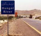 The turnoff to the volcanoes is 38 km short of Hungol (also pronounced as Hingol) river. A 1×1 ft board here says ‘Sapt Post’. Get off the road at this sign and follow the dirt tracks towards Arabian Sea and you’ll reach the mud volcanoes.
The signboard photo to the right above is the place where Makran Coastal highway meets River Hungol.
7 out of the 18 mud volcanoes are located few kilometers from the Sapt post as mentioned above, where as rest of the 11 mud volcanoes are located further west between Kutch and Gwadar.
There are two known groups of mud volcanoes here. One is called ‘Chandargup’ and other is called ‘Jabl-ul-Ghurab’. Very close to Chandargup is an ancient Hindu temple called ‘Hinglaj temple’ or ‘Nani Temple’. There are many pronunciations of the word Chandragup in practise. Due to close proximity a Hindu temple to these volcanoes, it is very likely that the word Chandargup is actually derived from the word ‘Chandargupt’. Another word which locally mentions this group of volcanoes is ‘Chandra coop’ which means Volcanoes of the Moon.
 It is said that mud volcanoes have roots that go several kilometers underground and act as safety valves for high underground pressure.
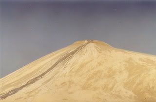
The photo to the left shows liquefied mud flowing out of 300ft hight Chandargup volcano in Hungol. It is said that liquified mud coming out of the volcano has healing powers. Many people come here to use this mud to cure skin diseases. This photo is from August 2003.
The earliest account of the presence of mud volcanoes in Balochistan dates back to 1840. 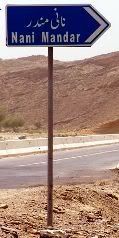
In 1862, Major (later Sir) Frederick John Goldsmid was employed by the Governer of Bombay for special missions. One such mission was a foray into Makran lasting from December 12, 1861 to January 1862.
The photo to the left is the signboard on Coastal highway N10 showing direction to ancient Hindu temples of Nani Mandir. The signboard is located at the eastern bank of River Hungol bridge.
Goldsmid and his party commenced their journey overland from Karachi and wrote a diary of their travels upto Gwadar.
This travelogue talks about the mud volcanoes, which gives the first surviving account of their existence. In his journal Goldsmid writes about passing through bubbling springs near Ras Koocheri, taking detours to see ancient Hindu temples of Hinglaj and the mud volcanoes near Ormara. The Hindus worship these mud volcanoes as the habitation of a deity Babhaknath.
It is reported that during the infamous 8.1 intensity earthquake of Balochistan which occured on May 31, 1935 a mud volcano erupted Northwest of Quetta, near the town of Surab and kept spewing out mud for 9 hours continuously.
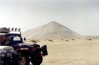
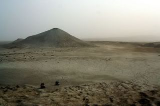
Photo to the right shows particpants of 4×4 offroaders club of Karachi with Chandragup mud volcano in the background. This Photo is dated back to August 2003.
It is also reported that on November 28, 1945 an earthquake of 7.8 intensity occured in Arabian Sea off the coast of Makran. The earthquake caused a tsunami with a wave reaching as high as 13m at some places. 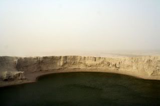 This tsunami killed 4000 people off the coast of Arabian Sea in Sindh and Baluchistan. Widespread destruction was reported in the towns of Pasni and Ormara.
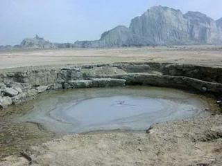
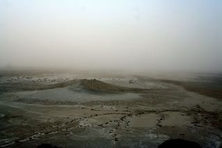
The photo to the left shows a water lake formed inside the crater of a mud volcano. This photo is from September 2005.
A village called Khaddi got completely wiped off the face of earth with no survivors. Even in Karachi, waves rose several feet through Clifton and Gizri. Sea water entered the compounds of oil storage facilities at Kimari harbor in Karachi. The underwater cable link which existed in 1945 between Karachi and Muscat was interrupted. The Cape Monze lighthouse, 72 km from Karachi, was damaged. The quake was also strongly felt at Manora Island near Karachi Harbour. The 94 feet high lighthouse on Manora island was damaged and a couple of pounds of mercury spilt.
 This earthquake shook and vented the mud volcanoes of Hungol so much that the gases coming out of this volcanoes got ignited and flames rose several hundred feet in the air.
The photo to the right shows a ground level mud volcano near Gwadar.
The news of fiery volcanoes erupting in Balochistan (1945) spread across India. There were also reports from RAF aircraft flying in from the west of volcanic eruptions in Lasbela State in Balochistan. A Britisher named Peter Martin Kaye who was stationed at Korangi Creek Royal Air Force Flying Boat base and his friend Peter Woolf, who was also stationed at the Korangi Creek base, took two weeks leave from the base commander and set off on the 2nd of December, 1945 on an expedition along the Makran Coast. They used camels provided by the Wazir of Lasbela State as transportation. Their mission was to check out what had happened when the earthquake and tsunami struck on Makran Coast. On reaching the location of three active mud volcanoes (which they called Chandragup, Ranagup and Rajagup), concluded that the quake had released a quantity of gas at that location which had ignited in a fiery eruption giving rise to the stories of volcanic eruptions.
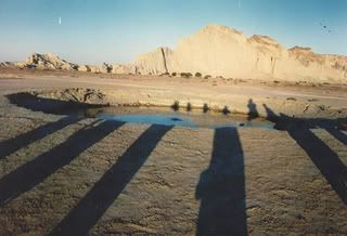
The photo below is the view of Gwadar mud volcano in setting sun. Shadows belong to the toursits. clicking on this photo will take you to its parent website.
 Another account of these eruption come from V.P. Sondhi, who in 1947 also wrote about the same volcanic phenomenon in the area near the mouth of the Hungol River in Baluchistan following the 1945 quake. According to Sondhi, the self-igniting plume of gas had erupted:
“with such great force that the flames leaped thousands of feet high into the sky.”
V.P. Sondhi also documented the emergence of three mud volcano islands in the Arabian Sea just off the coast of Makran. These off shore mud volcanoes didn’t live long and the strong wave action of Arabian Sea dissolved the muddy islands within months. 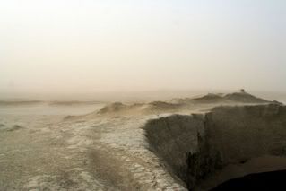 By the end of 1946 these mud volcanoes were completely gone.
Photo to the right shows crater edge of one of the Chandargup mud volcanoes. This photo is from September 2005.
The geological research says that the mud volcanoes emerging out of Arabian Sea are made from highly viscous mud with high gas content. The mud gets driven up by high buoyancy forces and over time, a high mud ridge or mountain forms out of the water.
A scientist named G. Delisle had described in 2002 the emergence of a new mud volcano island in March 1999 at about the same place, this time apparently not accompanied by an earthquake, but it was also destroyed by wave action a few months later.
 The photo to the left shows birds eye view of Hungol plain from top of one of the Chandargup mud volcanoes. A smaller mud volcano is clearly visible. This photo is dated September 2005.
Mud volcanoes are generally not considered to be dangerous. In some countries like Azerbaijan which has the largest concentration of mud volcanoes in the world, the gas eruptions from mud volcanoes are more frequent and violent than those in Pakistan, they are actually a tourist attraction. Should Pakistan do the same?
 With the opening of N10 – Makran Coastal Highway in 2004, mud volcanoes of Balochistan are now within few hours reach from Karachi.
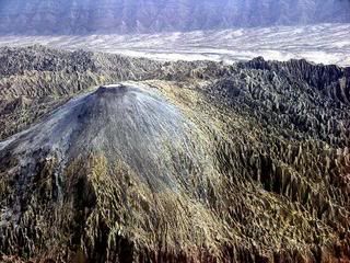
Photo to the right is a distant view of Chandargup mud volcano
The convenience of a world class highway is also bringing a constant stream of ‘city slickers’ to this once remote area. People are now climbing onto these sandy volcanoes in large numbers. Some preservation should be provided to these natural wonders otherwise the onslaught of tourist will deface the natural beauty.
Tourism should be allowed but within safe distance of these sandy monuments. I also recommend a visit to these volcanoes and not to mention the joy of travel on scenic Coastal Highway, which deserves a full post on its scenic route alone.
References:
- 4×4 Offroaders Club Karachi’s website.
- Rare Maps of Pakistan by F.S. Aijazuddin
- Clicking on most of the photos in this article will take you to their source websites and larger image sizes.


Кратко о Monro — Monro — По промокоду Monri777 бездеп для новичков — проверял, условия в кассе.
Регистрация через почту или телефон, можно через соцсеть — выбираешь один раз.
Pragmatic, Evolution, NetEnt, Play’n GO — фильтры по студиям работают быстро.
Активный бонус сначала отыграй, потом заявку — так меньше вопросов от поддержки.
Зеркало Monro Casino только из рассылки или чата — не из поиска.
Приложение на Android и iOS с главной страницы — поставил, push на выплаты включил.
Кто играет в Монро — как вам турниры и кэшбэк до 10%?