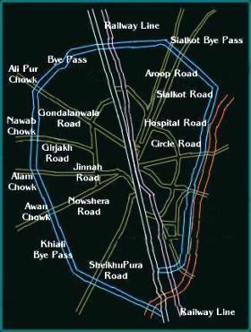
 Three episodes ago, we started our journey on Pakistan’s longest highway N5 in Karachi (km 0). On our way we stopped at Rohri, Bahawalpur and Lahore. Today in Part IV we will continue our journey on N5 northwards of Lahore (km 1260) and cover a distance of 280 km to reach Rawalpindi (km 1540). See the map to the right for our journey today. This portion of N5 along with Multan-Lahore and Rawalpindi-Torkham portion is part of the historic Grand Trunk Road.
Shahdara: (N5 kilometer Marker 1268)
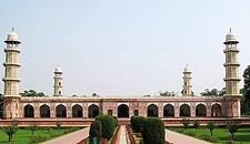
Lahore is located on East bank of River Ravi. N5 crosses the river and immediately enters the city of Shahdara located on its west bank. For all practical purposes now, Shahdara has become part of the Lahore city proper but technically it is still a separate town. Shahdara is famous for 3 Mughal dynasty mausoleums located here. These belong to Emperor Jahangir, his wife Nur Jahan, and her brother Asif Khan (also known as Asif Jah).
Following is a satellite image of Shahdara area. It shows N5 as well as a spur road goint to the mausoleum complex. This side road also crosses the railway line as an overhead bridge, so it is hard to miss if you are going there for the first time.

Asif Khan was the father of famous Mumtaz, the lady of the Taj Mahal at Agra (India). Over the years, Asif Khan‘s tomb has dilapitated to such a degree that most of its decoration is gone.
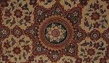
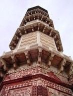
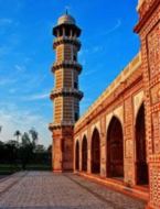
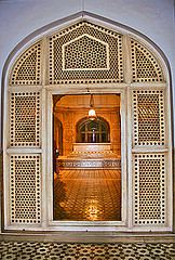
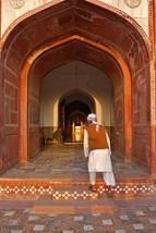
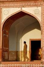
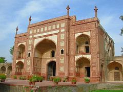 Jahangir‘s tomb however, has retained most of its splendour. It is magnificient and decorated with pietra durra. The 99 names of God are inlaid in black on the marble and there are beautiful jalis (mesh) which make even more beautiful patterns of light.
 Jahangir‘s wife Nur Jahan, was a power in the court and apparently much loved. It is said that when Jahangir was young man he handed the lady two of the royal pigeons to hold. While pigeon-flying may not be a cult in many countries, it was (and is) a sport enjoyed by many in the sub continent. When Jahangir returned for his birds, one had flown. He was surprised.
“But how did it fly?”
he asked.
“Like this!”
She laughed and let go the second bird. They say that from then on he was enchanted.
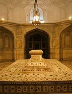
Nur Jahan‘s tomb was stripped down to bricks by the Sikhs, but was restored in the 20th century. In buildings of this sort, the actual grave is beneath the mausoleum, in the cellar.
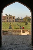
I have passed through Shahdara countless times but the last time I visited Jahangir, Nur Jahan and Asif Khan‘s mausoleums was way back in 1984. I remember eating ‘Mughlai murgh cholay’ (Mughal Chicken and Garbanzo beans) with tandoori naan in the lawn of tomb complex. We had bought this mouth watering lunch from one of the many ‘thelas’ (mobile vendors) that crowd the gates of Jahangir’s mausoleum.
Besides these Mughal mausoleums, Shahdara is also an important junction point for both road and railways. The road and rail branches from here go to Narowal in one direction (NE) and to Sheikhupura (SW) in other. N5 on the other continues Northward.
Muridke: (N5 km marker 1285)
This town is famous for Lahore Country Club Cricket ground which has been hosting regular First Class Matches in Pakistan. A side road off N5 also connects Muridke to the city of Narowal.
Kamoke: (N5 km marker 1307)
Kamoke is best known for Basmati brand rice market. One of the best quality Basmati rice is produced in fields around the city. According to a 2002 estimate, population of Kamoke was 167000 which gave it a rank of 31 among big cities of Pakistan. A satellite image of Kamoke is below.

According to unconfirmed source, Kamoke is named after a person named ‘Kamoo’ and the city was established during the time of Emperor Akbar (1542-1605 A.D).
Gujranwala: (N5 km marker 1328)
 Gujranwala is the 7th largest city of Pakistan. According to 1998 census, the city population was 1132500. N5 business loop goes through the city center but since early 1980s, N5 bypasses were built on both sides of the city. One has to take the old business loop to through the city to get a real flavour of Gujranwala. The city is named after a community of people called Gujjars. Gujranwala is also famous for its wrestlers and body builders.
 Gujranwala is also a road junction to go to Sialkot and Faisalabad via Sheikhupura. Before Motorway M3 was constructed, Gujranwala used to be the main junction for road traffic between Faisalabad and Rawalpindi.
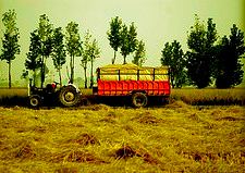
Photo to the left is the raw rice crop freshly cut in Gujranwala suburbs.
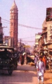 Another famous landmark from the city is the historic Estcourt clock tower. Shown in the photo to the right. The original name is almost archaic now and it is now famous as the ‘ghanta ghar’.
Other landmarks in Gujranwala include the Jinnah Cricket Stadium which has hosted numerous First Class and One Day International matches. Gujranwala is also a main railway stop on Pakistan’s mainline. Gujranwala is served by the newly constructed Sialkot International Airport.
Ghakhar: (N5 km marker 1347)
The word ‘Ghakhar’ comes from a community that goes by the same name, who is said to be the forefathers of Ghakhar City. This tribe lived at the north bank of Jehlum River. The city is famous for its finest duree factories which makes world class rugs, carpets, durees, and other cotton products. A satellite image of Ghakhar is given below.

Wazirabad: (N5 km marker 1362)
Just like Gujranwala, N5 bypasses Wazirabad City to the south. To go into the city one has to take N5 Business loop. Wazirabad is a road and rail junction to travel to Sialkot (NE) or Faisalabad (SW).
Satellite image of Wazirabad is below.

It is said that the city was founded by one, Sheikh Ilm-ud-din Ansari who was the court physician of Emperor Shah Jehan and later became the Governor of Lahore. The name Wazirabad is derived from his title of Wazir Khan.
Wazirabad is internationally famous for its fine quality medical/surgery tools as well as cutlery products such as hunting knives, pocket knives, daggers, swords, axes, laguiole knives, military knives, utensils, table cutlery, household and light industry products.
 Wazirabad is served by the newly constructed Sialkot International Airport. The airport is only 15 km from Wazirabad off highway N5.
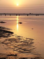
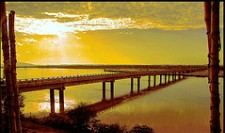
Just north of Wazirabad, N5 crosses the famous River Chenab. An image of these bridges over a setting sun is shown to the left. Below is the satellite image of N5 bridges over River Chenab below. One of the two bridges to the right is Railway bridge over Chenab.

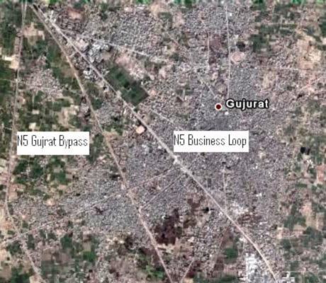
Gujrat: (N5 km marker 1380)
According to a British historian, General Cunningham, Gujrat was founded by Raja Bachhan Pal in 460 BC, which makes it a very historic city. The modern city of Gujrat however, was established around 1900.
 According to 1998 census, population of Gujrat was 252000 which made it the 18th largest city of Pakistan.
Gujrat is also known for its clay and thus the high quality pottery produced here. The city is also famous for its furniture industry as well as the high quality electric fans industry.
N5 has a bypass built around Gujrat. To go into the city one has to take N5 Business Loop. Here is the satellite image of Gujrat area.
Gujrat is also served by the newly constructed Sialkot International Airport. There is a new bridge on Chenab underconstruction these days. The bridge is called Shahbazpur bridge and it is located north east of Gujrat. Once complted, it will connect Sialkot airport to N5 at Gujrat. The drive time from N5 at Gujrat to the airport is estimated to be only 15 min.
Lala Musa: (N5 km marker 1397)
Lala Musa is a main junction on both N5 and railways to go to Malakwal and Sargodha. From my childhood road trips through Lala Musa, I’ve got vivid images of a children’s playground that used to be right next to N5. The playground had a slide and many swings. It used to be my fantasy to one day stop there and enjoy the ‘jhoola’s but my father never stopped car there. After I became old enough to drive on N5 myself, I was also too old to use slides and swings in a children’s park in Lalal Musa, but the memories of childhood still continue to remain with me.
Kharian: (N5 km marker 1412)
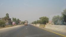 Kharian is home to Pakistan’s second largest cantonment. A road from Kharian goes to the famous Mishri Mor Buss Adda. Photo to the right shows N5 passing through Kharian.
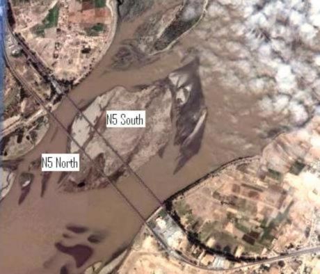
Sarai Alamgir: (N5 km marker 1426)
This city is located on the eastern bank of River Jhelum. It is said that the actual town of Sarai was founded by the Mughal emperor Aurangzeb Alamgir because of its strategic location on the Grand Trunk Road. The South Eastern boundary of Sarai Alamgir is marked by Lower Jhelum Canal.
Following is the satellite image of N5 bridges over River Jhelum which connect Sarai Alamgir to the city of Jhelum.
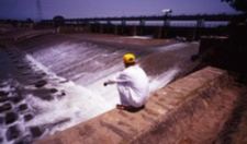
Following two photos show the Jaggu Head Works in Sarai Alamgir and the N5 bridge over Jhelum.
Jhelum: (N5 km marker 1432)
Jhelum city is located right across Sarai Alamgir on Northern bank of River Jhelum. The city of Jhelum and adjoining areas have been extensively covered in various posts at ATP before so we will just provide links to those posts here.
1. Hydaspes -> Boucephila -> Jhelum
2. Jhelum – The City of Vitasta
3. Cultural Fusion at Mishri Mor Buss Adda
Dina: (N5 km marjer 1448)
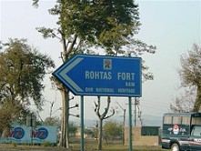 Dina is a very important junction point of N5. One road from here goes to Mangla Dam and to Mirpur in Azad Kashmir and another goes to Rohtas Fort. Photo to the left is Rohtas Fort direction marker on N5. I’ve had several memories from this little town. My earliest memory is from in 1980 when we took Tezrau from Lahore for Dina. Tezrau used to have only a 2-minute stop at Dina. We descended from the train in haste along with the luggage. From Dina we continued our journey to Mangla via bus. My latest memory of Dina is from 1990s. I was staying in Mangla for vacations and used to drive down to Dina every evening to have ice-cream. Dina was the only city in the vicinty that sold ice-cream.
Sohawa: (N5 Km Marker 1473)
Just outside Dina, N5 gains altitude and goes through beautiful hilly area of Potohar region. N5 used to be very curvy-twisty here until 1996. Around that time, many portions of hills were cut to ease out the curves and gradient, especially around a village called Tarki. Today N5 is a lillte bit less dramatic in this area than it used to be. Sohawa is the next big town of N5. A road junction on N5 from Sohawa goes to the city of Chakwal and passes through the heartland of Potohar region.
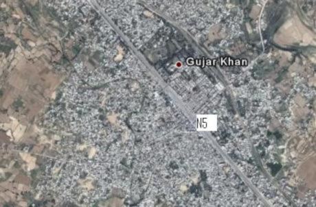
Gujar Khan: (N5 km marker 1491)
Satellite image of Gujar Khan is below.
Mandra: (N5 km marker 1505)
A road junction on N5 from Mandra goes to the city of Chakwal. Satellite image of Mandra alongwith the road junction to Chakwal is shown below.

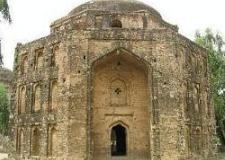
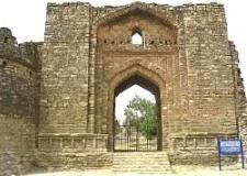
Rawat: (N5 km marker 1522)
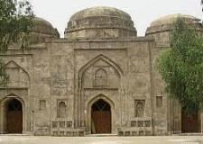 There is a historic Ghakkar Fort near the town of Rawat (or Riwat) on N5. Currently what remains of the Fort is just the entrance gate and ruins of the surrounding wall. It is worth a trip in my opinion anyway. Photo to the left is a historic Ghakkar era mosque and below are the two photos of Ghakkar Fort.
Islamabad Highway Junction: (N5 km marker 1524)
At km marker 1524, a junction to the right on N5 takes us to Islamabad. This road to Islamabad is also called the Islamabad Highway and enters Islamabad at Zero-Point.
Rawalpindi: (N5 km marker 1540)
The city of Rawalpindi and adjoining areas have also been extensively covered in various posts at ATP before so we will just provide links to those posts here.
1. Rawalpindi – Past and Present
2. Remembering Ojhri Camp
3. heartland of Potohar region
This completes our travel for today. We will now embark on last part of our journey on N5 in episode V soon.
ATP brings you the Complete Story of Travel on N5:
1. Traveling on N5 – I: Karachi to Rohri: 483 km
2. Traveling on N5 – II: Rohri to Bahawalpur: 361 km
3. Traveling on N5 – III: Bahawalpur to Lahore: 417 km
4. Traveling on N5 – IV: Lahore to Rawalpindi: 272 km
5. Traveling on N5 – V: Rawalpindi to Torkham: 216 km
Also see
1. Sukkur to Quetta by Highway N65
References:
1. mongabay.com
2. Photos for this post are taken from Flickr.com
3. Satellite Images for this post are taken from Google Earth.


Thanks for your write-up on this site. From my personal experience, often times softening way up a photograph might provide the photographer with a little bit of an imaginative flare. Sometimes however, this soft cloud isn’t precisely what you had in mind and can frequently spoil a normally good photo, especially if you thinking about enlarging it.
df31uv
S.A.J. Shirazi writes a short blog on N5’s GT road portion here
As far as I understand that the name SHAHDARA has two parts
first is SHAH…. and the next is….. DARA.
SHAH means the KING …… and DARA reflects the meaning of DOOR (Darawaza).if we combine these two words.. then we can say it is the door or darawaza from where any one enter into the Mahal or Fort..Gateway to enter in the King place.
To Pervaiz Munir Alvi.
I have found evidence of your position on the name of Shahdara. The name of that place near Lahore is mentioned in the Akbarnama of Abul Fazl. My mis-information was obtained from a few articles by Majid Sheikh in Dawn and other places.
I would edit my comments here if I could.