Five episodes ago, we started our journey on Pakistan’s longest highway N5 in Karachi (km 0). Today is the last episode of our travel and after covering 216 km we will reach the end point of N5, which is Torkham (km 1756) – the border between Pakistan and Afghanistan. Following are the maps of the travel that we will cover today.
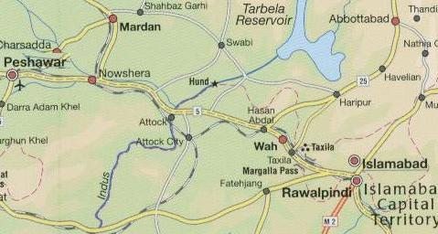
Rawalpindi to Peshawar:
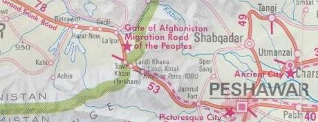
Peshawar to Torkham via Khyber Pass:
Let us resume our journey north west of Rawalpindi at N5 Kilometer Marker 1551 which is called the ‘Golra Mor’ junction to Islamabad.
Road Junction to Islamabad (N5 Km Marker 1551):
11km North-West of Rawalpindi city center, this is an intersection called ‘Golra mor’ form where ‘Kashmir Highway’ takes you to Islamabad. This is also the intersection to go to Golra which is famous for a saint called Pir Mehr Ali Shah buried here as well as for Pakistan Railway Heritage Museum.
Tarnol (N5 Km Marker 1555) and New Islamabad Airport:
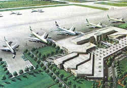 Tarnol is the road juction for going to Kohat. 144 km long Highway N80 connects Tarnol to Kohat. Islamabad’s new International airport is also located near Tarnol towards Fateh Jang. Work started on new Islamabad airport in April 2007 and it is expected to be completed in 2010. The new airport covers an area of 3600 acres and is expected to handle 6.5 million passengers per annum and 80,000 metric tonnes cargo per annum. Estimated cost of the airport is US $400 million.
Sangjani (N5 Km Marker 1561):
John Nicholson’s Obelisk (N5 Km Marker 1565):
 Just west of Rawalpindi, N5 passes through the Margalla Pass. Here N5 slices through the rocks. A large obelisk on the hill is a memorial to John Nicholson, a general who fought against the Sikhs, gained respect from them, and eventually made a magnificient dash to Delhi in 1857, where he fell. The obelisk recorded that he was
“mourned by two races with equal grief”
So well regarded was Nicholson that he left a religious group of followers called the Nikalsenis.
Taxila and business Loop to Wah Cantt (N5 Km Marker 1569):
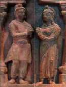 While the main attraction is Taxila are the archaeological remains of great cities and stupas, the valley in which it all lies is arguably one of the most beautiful in Punjab.Taxila has a number of shops selling local, decorated pots and there are some stone masons who sit hammering at rocks, carving out pestles and mortars which are for sale. Taxila has so much to offer that we promise to bring a separate post on its archaeological treasures. A paragraph in this post can not do justice to Taxila’s heritage. In the past, we did do a quiz post on Taxila Museum here.
Multiple locations in and around Taxila were declared World Heritage Site by UNESCO in 1980.
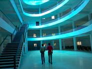 Taxila is also famous for Pakistan’s 6th ranked (in 2006) University of Engineering and Technology Campus located here. Photo to the right is inside view of the Digital Library at UET Taxila.
According to 1998 census, population of Taxila was 48115 and Taxila cantonment was 23653.
Wah Cantt (N5 Km Marker 1579):
 The city of Wah has grown so much over the years that it connects to Taxila on one end and to Hasan Abdal on the other. One of the landmarks I remember from passing through Wah Cantt is the ‘Jama Masjid’ which is very close in architecture to Delhi’s Jama Masjid or Lahore’s Badshahi masjid.
Pakistan Ordnance Factory (POF) which is the largest Ordnance factories in the country is also located here.
According to 1998 census, population of Wah cantonment was 198431.
Mughal Gardens:
 Also just outside Wah, a turn to the left on N5, leads up a ravine and takes you to Mughal Gardens. The garden is no rival to Lahore’s Shalamar Gardens, but still it is a pleasant place. It is also a good place to admire the architecture, which is so suited to the heat of northern plains.
 The shady Walled Garden was a resting place for Mughal rulers during their travels to the north or after hunting expeditions nearby. The garden is laid out with geometric precission. Together with the ruins of the Mughal courtyard and a platform where the emperors amused themselves, there are interconnected tree-lined waterways, ponds and waterfalls.
Government of Pakistan gave this garden complex to Archaeological Department in 1976.
Hasan Abdal (N5 Km Marker 1585):
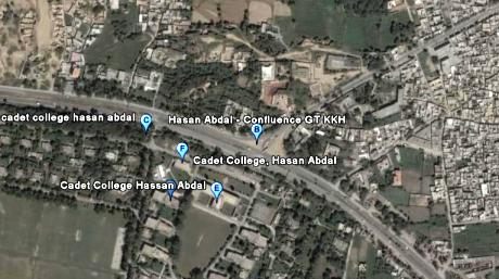
Hasan Abdal is a junction on N5 (and terminal point) for the famous 806 km long Karakoram Highway (N35) which connects Pakistan to China. The satellite photo below shows the terminal point of N35 on N5 in Hasan Abdal.
We’ve covered Hasan Abdal at ATP in following posts:
1. Panja Sahib: The Miracle at Hasan Abdal
2. Panja Sahib: The Miracle that Refused to Happen
3. Going Pink in Hasan Abdal
According to 1998 census, population of Hasan Abdal was 37789.
Burhan (N5 Km Marker 1595)
Burhan is a place where N5 and Peshawar – Islamabad Motorway M1 can be interchanged. M1 has an exit/ramp here.
N5 crosses River Haro north-west of Burhan
Sanjwal Cantt (N5 Km Marker 1601.012)
Road Junction to Attock City (N5 Km Marker 1601.014)
A road junction at N5 from here goes to Attock City (previously called Cambellpur)
Lawrencepur (N5 Km Marker 1602)
Lawrencepur is famous for the high quality woolen fabrics produced here.
Road Junction to Ghazi Barotha and Tarbela Dam (N5 Km Marker 1603)
From N5, this road starts off in North-East direction. After this road junction, N5 crosses the Ghazi Barotha Canal.
Hattian (N5 Km Marker 1609)
Road Junction to Hazro and Ghazi Barotha (N5 Km Marker 1610)
From N5, this road starts off in North-East direction.
Road Junction to Attock City (N5 Km Marker 1610.014)
A road junction at N5 from here goes to Attock City (previously called Cambellpur). From N5, this road starts off in South West direction.
Kamra (N5 Km Marker 1611)
Goundal (N5 Km Marker 1618)
A road junction from Gondal goes to the city of Hazro
Haji Shah (N5 Km Marker 1619)
A road junction at N5 from here goes to Attock City (previously called Cambellpur). From N5, this road starts off in South West direction.
Attock (N5 Km Marker 1621) [Also called Attock Khurd]
Attock Khurd is located on east bank of River Indus. The work ‘khurd’ means small. The city is called ‘khurd’ because there is a bigger Attock located few kilometers south-east called Attock City. Attock City was previously called Cambellpur.
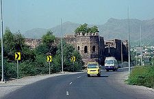
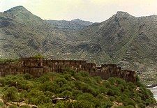 Attock khurd is famous for a fort located here. Photo to the left. The fort sprawls across the hillside looking over the river Indus. The Indus at Attock enters a gorge and continues through it for some miles down to Kalabagh. The fort rises in steps reaching a great height above the river. The outer stone walls are nearly 2km (1.5 mi) in circumference. The fort was built during the time of Emperor Akbar when he was having troubles with a rebellious brother who was holed up in Kabul. Attock Fort superseded Rohtas Fort. It was taken by Ranjit singh and by the British. It is also the birthplace of Sir Anthony Eden, who later became British Prime Minister. Unfortunately it is not possible to visit the fort as it is not open for tourists.
After Attock N5 crosses the River Indus via two separate bridges for N5 North and N5 South.
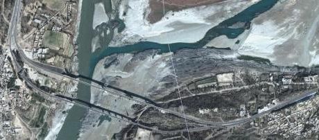
In the photo above, one can clearly see the meeting point of two rivers, Kabul (left) and Indus (right) just above the N5 bridges.
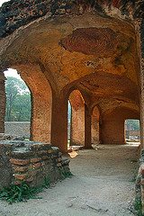
 Just to the east of these bridges, and even more impressive than the fort itself, is the caravanserai of Sher Shah Suri. See photo to the left. The rooms of the caravanserai were built into the walls, which surround a large square courtyard. It is possible to climb onto the walls for some fine views of the Indus and up to the fort rising from behind.
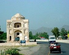 Also on N5 in Attock, one also passes next to the tomb of an unknown dancer. The tomb is also date back to the time of Emperor Akbar. See photo to the right. You can see N5 North passes right next to the tomb.
ATP had following posts in the past which talk about Attock area and the railway bridge over Indus at Attock.
1. When Kabul Comes to Attock
2. The Bridges of Pakistan
Jahangira (N5 Km Marker 1638):
A small town with historical significance of Sikh era. A battle was fought here in 1823 between the Sikh Army and the Afghans. From Sikhs, Sardar Nalua, Akali Phula Singh, Gorkha Bal Bhadra, Mian Ghausa, Misr Diwan Chand, Sardar Attar Singh marched in the battle field at the head of their divisions and gave a defeat to the Afghans in the battle. Another decisive battle was fought in the same year at Nowshere which is mentioned below.
Nowshera (N5 Km Marker 1657):
Most notable landmark on N5 in Nowshera is the famous Taj Building. It was built in 1920 and is declared a protected heritage by the Government of NWFP. Photo below:

Nowshera is pronounced locally as ‘Nau khaar’. Famous poet Khushhal Khan Khattak was born in Nowshera. Two other famous and notable Pushto poets viz., Mr. Samandar Khan Samandar and Mian Said Rasool Rasa belongs to village Badrashi on the outskirts of Nowshera City.
Under the British, Nowshera became an important cantonment town, a base for troops fighting in the Khyber Pass and patrolling all along the North-West Frontier. Nowshera is also the place where Ranjit Singh’s army inflicted a massive defeat on the Afghans in 1823.
The Tomb of the famous Sikh Commander Phula Singh is located in Nowshera City.
Places to see in Nowshera include Jinnah Park which is located on the banks of River Kabul and also hosts a mini zoo with few nesting peacocks.
According to 1998 census, population of Noawshera was 89428.
Pabbi (N5 Km Marker 1678):
Pabbi is an idyllic agricultural village on the outskirts of Peshawar. I have very fond personal memories of stopping on the roadside of N5 in Pabbi in summer of 1980 and then taking a cool bath in the village Tube Well which had a pipe diameter of almost 6 inches. The temperrature that day must’ve been in 40s and our card had no AC. On seeing this roadside tubewell in Pabbi, we bathed with our clothes on so that water could keep us cool longer.
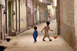
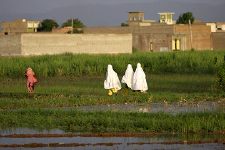
The above two photos are from the Pabbi village and credited from here.
According to 1998 census, population of Pabbi was 30946.
Peshawar (N5 Km Marker 1700):
According to 1998 census, population of Peshawar City was 982,816. Peshawar requires many articles just describing the beauty and historical signinficance of the City. ATP has covered portions of Peshawar in following articles, which I’d like to present here:
1. Masjid Mahabat Khan, Peshawar
2. How Islamia College Peshawar Lost its kullah
The Khyber Pass:
 After Peshawar, N5 passes through one of the most famous passes of the sub continent, the Khyber Pass. Few passes have held more strategic importance than Khyber Pass in history. Many nationalities like Afghans, Mughals, Greeks and Persians have passed through it on their way to conquest India and British passed through it the other way round. In the 5th century BC the Persian ruler Darius the Great marched through the pass on his way to the River Indus.
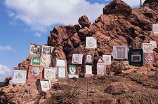 Photo to the right shows insignia of regiments that have served Khyber Pass from the British days.
There is some reference in books that Alexander the Great’s army may also have used Khyber Pass on its brief foray into the sucontinent. There was no road through the pass until the 16th century when, under Akbar, Kabul was finally linked to Delhi by the Grand Trunk Road. It is the same road which now forms the highway N5 through the Khyber Pass.
Jamrud (N5 Km Marker 1718):
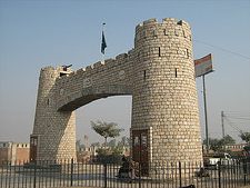 Jamrud is most famous for its monument called the ‘bab-e-Khyber’ (Gateway to Khyber) which was built in 1964. The image of this monument is perhaps the most circulated image of anything related to NWFP in Pakistan.
There is also a fort at Jamrud which was originally built by the Sikhs in 1823. The walls of this fort are more than 10 ft (3m) thick. The fort is associated with the Sikh hero Hari Singh Nalwa who was killed here, fighting the Afghans. He was alsr cremated in the fort.
Shagai Fort (N5 Km Marker 1725):
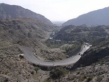
This fort was built by the British and is still in use by the Frontier Force and thus closed to public. Three kilometers out of Shagai Fort is the best viewpoint of the Khyber Pass on N5. Looking back towards Peshawar, two roads can be distinguished; the top one is the one for vehicles. The lower route is the older and historic one, traversed by people, camels and donkeys.
A little bit further west, there is a viewpoint offering a vista of the World Famous Khyber Pass Railway.
Ali Masjid Fort:
I am unable to research kilometer marker for Ali Masjid except it is located North West of Shahgai Fort. Ali Masjid is located in the narrowest portion of the pass said to be only 17 ft (5 m) wide. The highway N5 has subsequently been widened here but it remains the narrowest point on the pass. High above Ali Masjid is located the Ali Masjid Fort which defends this narrowest portion of the pass.

Landi Kotal (N5 Km Marker 1750):
Located at an altitude of 1100 meters/3500 ft, Landi Kotal is the top of the Khyber Pass. There is a Central Asian caravan-serai and a fort garrisoned by the Khyber Rifles.
Michni Post:
Just couple of kilometers west of Landi Kotal is theMichni Post. This is the farthest point on N5 up to where foreign visitors to Pakistan are allowed to go. It offers superb views through the Western Side of the pass to Torkham
Torkham (N5 Km Marker 1756):
Torkham is the border post between Pakistan and Afghanistan and it is also the end point of N5. A journey on N5 that starts from the shores of Arabian Sea in Karachi ends in the arid heights of Torkham 1756 kilometers later.
CLOSING REMARKS:
N5 is not only the longest highway of Pakistan but also the backbone of country’s economy as well as a means of communiation which naturally promotes National harmony and interaction. This is indeed the highway where one can see all flavors of Pakistan and where Iqbal’s poetry comes to life when he said:
Hawas ne tukre tukre kar diya hay na’u insan ko
ukhuwwat ka bayan ho ja mohabbat ki zaban ho ja
ye Hindi, wo Khurasani, ye Afghani, wo Turani
tu ay sharmindayeh sahil uchhal kar bekaraan ho ja
ATP brings you the Complete Story of Travel on N5:
1. Traveling on N5 – I: Karachi to Rohri: 483 km
2. Traveling on N5 – II: Rohri to Bahawalpur: 361 km
3. Traveling on N5 – III: Bahawalpur to Lahore: 417 km
4. Traveling on N5 – IV: Lahore to Rawalpindi: 272 km
5. Traveling on N5 – V: Rawalpindi to Torkham: 216 km
Also see
1. Sukkur to Quetta by Highway N65
Photo Credits:
1. Kamran Safdar here for photo of Jack Nicholson’s Obelisk
2. Samiullah Khan here for photo of Wah Cantt Mosque
3. Mahmood Aslam here for photo of Taj Building, Nowshera
References:


Very intresting and informative site. I learned a lot and got too much help from this site for preparing an assignment.
It was British politician Rab Butler who was born at Attock Sarai and not Sir Anthony Eden as mentioned in your write up