In November 2009, we started our virtual journey on N55 Indus Highway from its zero point at Jamshoro (N55-Part I) and today after 13 months of stop and go journey we will hopefully reach its end on the Ring Road of Peshawar. When we reach there we will have covered 1256 km.
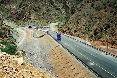
Following photo is N55’s approach to Friendship tunnel between Kohat and Dara Adam Khel – one of the landmarks you’ll see on today’s travels.
For a quick recap, in Part II we had traveled on the right bank of Indus and driven 333 km to reach Dera Ghazi Khan (N55-Part II). In Part III we covered further 214 km to reach Dera Ismail Khan (N55-PartIII) . Lets try to reach Peshawar today. It is 334 km from here and it reminds me of a naara which I once heard from participants of a juloos (procession) in Liaqatabad, Karachi which was going Peshawar “by foot” in 1990. One of their leaders was shouting on megaphone “Peshawar dur hai” and everybody else in the procession replied in chorus “jaana bhi zaroor hai”. These guys were apparently doing Karachi-Peshawar long march for some unknown demands. I was passing by on my Yamaha 50 and all I remember was this naara. So for us today on N55 – after a gap of 20 years – lets raise the same slogan again:
Peshawar dur hai
jana bhi zaroor hai
Today we’ll start our journey just north of Dera Ismail Khan and the first town that we’ll pass through is called Yarak.
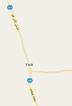 Yarak (km marker 964)
Yarak is a small village 33 kilometers north from D.I.Khan city center. From Yarak a small road branche off from N55 towards east and goes to Chashma Right Bank Canal. Yarak is also sometimes spelled and pronounced as ‘Yarik’.
Kulachi N55 Link Road (km marker unknown)
Few kilometers north of Yarak, this link road branches to the West and meets D.I.Khan-Tank road at Gara Hayat and then connects to the town of Kulachi.
Lucky Cement Factory (km marker unknown)
Just few kilometers before Pezu, Lucky Cement Factory is located on the east side of N55.
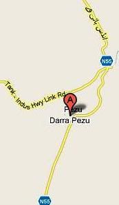 Pezu (km marker 990)
Pezu is a junction point for a link road to Tank which branches off from N55 towards west.
Shahbaz Khel (km marker unknown)
Tittar Khel (km marker 1011) (also called Tattar Khel and Guli Jan)
Ghazni Khel (km marker 1017)
Ghazni Khel is a junction point with link roads leaving east and west off N55. The road to the east connects to a town called Kaka khel and the road to west connects to a town called Khaira Khel.
Laki Marwat Link Road Junction (km marker unknown)
Few kilometers north of Ghazni Khel, another east-west link road connects N55 to Laki Marwat towards east and Khair Khel towards West.
Tochi River N55 Bridge (km marker unknown)
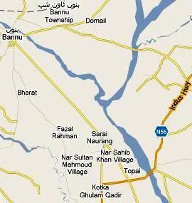 Sarai Naurang (km marker 1048)
The new alignment of N55 does does not enter Sarai Naurang but few kilometer before the old town center it takes a sharp right to bypass the town. The old alignment of N55 (now called Bannu Road) goes to Sarai Naurang and then onwards to Bannu.
Bannu (km marker 1073)
Bannu was served by the old alignment of N55. Currently the highway bypasses the city but there are link roads which connect the city center to N55.
Bannu is also the largest town on this section on N55 between D.I.Khan and Kohat. Bannu’s population including the cantonment in 1998 was 46896.
The present day Bannu city was fiunded in 1848 by a Britisher Sir Herbert Edwards and therefore it was initially called Edwardsabad. For some years it was also called Dhulipnagar (or Dalipnagar) named after its main bazaar as well as Dhulipgarh (or Dalipgarh) named after its fort, before its current name Bannu took over.
Bridge over Kurram River Tributary (km marker unknown)
Latambar (km marker 1011)
Latambar is also bypassed by the new N55 alignment. The old N55 – now called Bannu Road connects Latambar town to the new alignment.
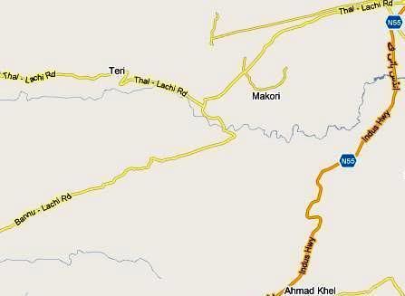
Bahadur Khel (km marker 1117)
Khurram Muhammad (km marker 1127)
Jata Ismail Khan (Km marker 1159)
The four towns listed above are located on old N55 aligment called Bannu-Lachi Road and Thal-Lachi Road. Some portion of old N55 is called Bannu-lachi and from a junction point onwards from where a link road heads to Thal it is called Thal-Lachi road. The new N55 bypasses all of these towns but runs in parallel to Bannu-Lachi and Thal-Lachi Roads.
Ahmad Khel (km marker unknown)
Ahmad Khel is located on N55 new alignment before the town of Lachi.
Lachi (km marker 1169)
Lachi is the junction where old alignment of N55 and new alignment meet again.
Gada Khel (km marker unknown)
North of Lachi, this is the junction point for a link road heading west to Hangu.
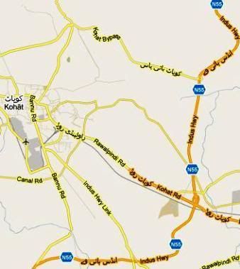
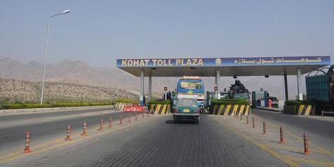
Kohat (km marker 1196)
 Population of Kohat including cantonment in 1998 was 125271.
N55’s new alignment has a bypass for Kohat and several roads from Kohat connect to N55. The old N55 alignment that goes into Kohat town is now called Bannu Road. Then there is Indus Highway Link Road, Rawalpindi Road, Kohat bypass Road, an unnamed road and Kohat Road which connect Kohat city center to N55.
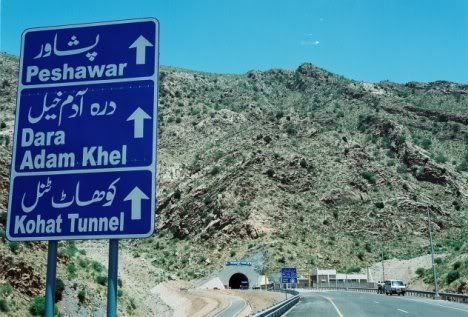
Friendship Tunnel (km marker unknown)
ATP had a very detailed post dedicated to Kohat Tunnel itself. Our readers can read it here.
This tunnel cuts down the distance between Kohat and Peshawar (and hence the length of N55) by 25 kilometers, which is definitely a great saving in time (40 min) and fuel for people traveling here.
A signboard on N55 near Friendship Tunnel on North bound road.
Dara Adam Khel (km marker 1220)
Matanni (km marker 1240)
Peshawar-Hayatabad Road Junction (km marker unknown)
Peshawar (km marker 1265)
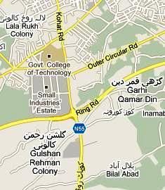 N55 ends in Peshawar (or starts from Peshawar in down direction) from a place called Gulshan Rehman Colony and Garhi Qamar Din located on Peshawar Ring Road. From Ring road to Peshawar City Center the old alignment of N55 is called Kohat Road. The map to the left shows the end (or starting) point of N55 at Peshawar Ring Road.
According to 1998 census, population of Peshawar City was 982,816. ATP has covered portions of Peshawar in following articles, which I’d like to present here:
1. Masjid Mahabat Khan, Peshawar
2. How Islamia College Peshawar Lost its kullah
And this completes our 1265 km journey on Pakistan’s second longest national higway – the N55.
References:
1) Google maps (googlemaps.com)
2) National Highway Authority, Pakistan (nha.gov.pk)
ATP’s Posts on the Road Network of Pakistan:
The Indus Highway N55 Series
1. Traveling on N55: The Indus Highway: Part I – Jamshoro to Shikarpur
2. Traveling on N55: The Indus Highway: Part II – Shikarpur to Dera Ghazi Khan
3. Traveling on N55: The Indus Highway: Part III – Dera Ghazi Khan to Dera Ismail Khan
4. Traveling on N55: The Indus Highway: Part IV – Dera Ismail Khan to Peshawar
The National Highway N5 Series
5. Traveling on N5 – I: Karachi to Rohri: 483 km
6. Traveling on N5 – II: Rohri to Bahawalpur: 361 km
7. Traveling on N5 – III: Bahawalpur to Lahore: 417 km
8. Traveling on N5 – IV: Lahore to Rawalpindi: 272 km
9. Traveling on N5 – V: Rawalpindi to Torkham: 216 km
Others:
10. Sukkur to Quetta by Highway N65
11. Friendship Tunnel, Kohat
12. RFID based E-Toll System on Pakistan Motorway
13. Peshawar-Islamabad Motorway M1 is inaugurated
14. Lyari Expressway inaugurated
15. GPS Automotive Navigation in Pakistan.
16. Lahore Ring Road Project


The atmosphere of this terpene blend – What specific terpenes in Blue Dream create its signature berry flavor is exceedingly sanitary and fundamental, not too strong but motionless clear in the overcome way. It blends smoothly and adds a much better flavor chart without oppressive everything else. Orderly a slight amount makes a argument, which says a plight with reference to the quality. The packaging was shielded, shipping was faithful, and the unimpaired experience felt reliable. Really congested outcome and a certain I’d joyfully disposal again.