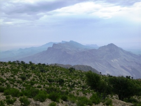
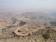
Do you know there is a place in Sindh where it snows in winter? Yes, there is one such place and it is called Gorakh Hill . It is located in Dadu District and has an altitude of 5500 ft. It is the highest place in the Kirthar range of hills (reachable by road) which also forms the provincial boundary between Sindh (Dadu) and Balochistan (Khuzdar) as a jagged backbone. The highest peak in Sindh is also located in the Kirthar range and is called ‘dog’s grave’ and has an altitude of 2174 m (7133 ft). Following is a breath taking view of Gorakh Hill. Photo credits belong to [2] below.
How to Reach There:
From Dadu city the top of Gorakh Hill is at a distance of 93 km. To reach Gorakh, one starts going west from Dadu. At kilometer marker 17 from Dadu, is a place called Johi which is a ‘tehseel’ of Dadu district.
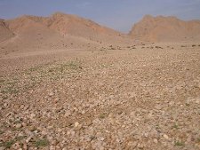
At kilometer marker 39 from Dadu is a village called Wahi Pandi which forms the base camp of Gorakh Hill. Wahi Pandi is a decent size village with a population of approximately 20,000.
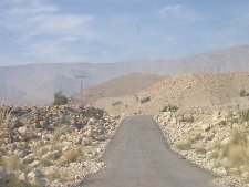
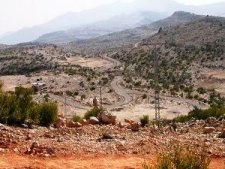
The photo to the left below shows landscape near Wahi Pandi. The photo to the right below shows a glimpse of single track road to Gorakh Hill
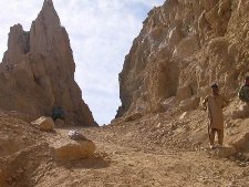
After Wahi Pandi the road gains altitude fast. At kilometer marker 53, the road enters a pass called the Yaro Pass. In Sindhi it is called the ‘Yaro saain jo lak’. Yaro pass is located at an altitude of approximately 2500 ft. At kilometer marker 76, the road enters yet another pass. This one is called the Khanwal Pass and it is 4 km long.
The photo to the left below shows road through Yaro Pass. The photo to the right below shows the starting point of Khanwal Pass

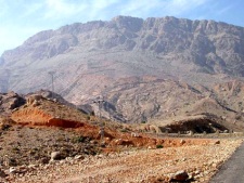
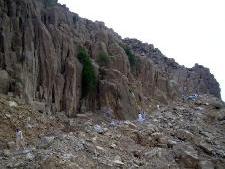
The lower end of Khanwal Pass is at approximately 3000 ft above sea level while the higher end of the pass is at approximately 5000 ft altitude. From the top of Khanwal Pass to the top of Gorakh Hill is a distance of another 13 km. (kilometer marker 93 from Dadu).
The photos below show different views of Khanwal Pass.
Coming from Karachi, there is a shorter route to Johi. A road from Sehwan Sharif on Indus Highway (N55) branches off to Johi at a distance of 40 km. This way you can bypass the city of Dadu and the route is 20 km shorter.
Accommodation at the Top:
There is a small rest house available at the top of Gorakh Hill but be prepared to do camping outside. According to Reference [1] below:
Out of the two rooms, only one can be used by guests, as the other one is being used as a store room. While the rest house is wired up, there was no electricity, probably due to heavy rains I presume. However, there is a back-up generator in working condition, but no water, so remember take a good amount of with you
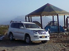
The photos below are courtesy of my friend Shabbir Ali Bijarani and show his camping trip to Gorakh Hill

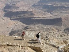
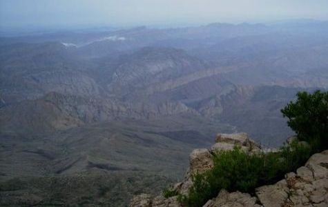
Gorakh Hill top gives a vast unhindered views of the Sindh and Balochistan landscape. According to [1]:
The sunrise is definitely worth viewing here. As the early rays of the sun hit the top one can see the gradual illumination of the beautiful valley of Wahi Pandi towards the east, while the Sindh-Baluchistan border lies visible towards the west.
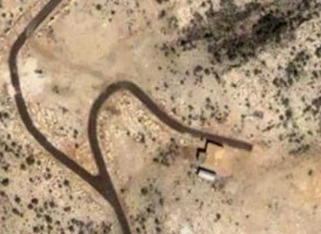
Satellite Images of Gorakh Hill:
The first image shows the road-end at the top of the Gorakh Hill as well as location of a small rest house.
The image below shows the location of Gorakh Hill by red arrow. The white line to the left is the Sindh-Balochistan border. Also note the winding road leading to Gorakh Hill

History of Development:
 Sometimes back in 1998, it was decided to make Gorakh Hill a resort for tourists at par with other hill stations of Pakistan located in North-Western Pakistan. The hill resort project included development of a waterfall, cable chair lift from the Gorakh hill to the Chokor hill, 10-beded hospital, water filter plant, security check post and a race course.
According to [4],
Despite passage of eight years and expenditure of more than Rs 200 million, the fate of the Gorakh Hill station project still hangs in the balance because of indifference of the government. The PC-1 of the project was revised and an amount of Rs 198.269 million was released on Feb 24, 2004. The funds were meant for constructing a road from Wahi Pandi to Gorakh hill at a cost of Rs 86.353 million, development of water supply scheme at the cost of Rs 34.636 million and purchasing vehicles and other equipment at a cost of Rs 8 million
Communications at the Top:
There are neither any land lines for telephone nor a mobile service available at Gorakh Hill. However, Pakistan Telecommunication Limited (PTCL)’s wireless service called the V-PTCL Wireless works at Gorakh Hill. Reference [1] below.
Weather:
In summers the day time temperature at Gorakh Hill reaches 25C but at night a drop of 20C to 5C is not unusual. Gorakh Hill gets occasional snowfall during winters too.
ATP’s Related Post on Another Tourist Spot in Kirthars:
Toshangi Gorge: The Grand Canyon of Sindh
References and Photo Credits:
[1] Gorakh Hill Station by Umair Ahmed Shaikh of 4×4 Offroaders Club, Karachi
[2] Gorakh Hill Photo by umashah79 here.
[3] Gorakh Hill Photo by ahashmi here.
[4] Gorakh Hill Project in doldrums
[5] Rakaposhi Hiking Club, Nawabshah
[6] www.googleearth.com
[7] Shabbir Ali Bijarani’s photos here


Till the dacoits were wiped out from Sindh dhurtee there can’t be tourism promotion.
But now We have a PPPP Home Minister who has very close relation with these dacoits and even done press conference sitting along with thme.
How can a dacoit partner can even thinking of wiping them off.
A couple of more news items about Gorakh Hill Station:
http://www.thenews.com.pk/print1.asp?id=182774
and the following copied/pasted from nation.com.pk ‘s website:
“‘Investors invited to explore tourism sector
Published: June 13, 2009 Karachi (PPI) – Sindh Chief Minister Syed Qaim Ali Shah has said that Pakistan and China are two friendly neighbouring countries and they have always worked for welfare and economic betterment of people of each country.
This he said while holding meeting with a 6-member Chinese (Hubei) delegation at Chief Minister House here last night.
Syed Qaim Ali Shah maintained that Hubei and Sindh are two sister provinces of peoples Republic of China and Islamic Republic of Pakistan, striving for the progress and prosperity of masses of both countries adding that there is capacity of development in various fields particularly in Information Technology, Tourism, Agriculture, Coal Mining, Power Generation and other fields.
Chief Minster stressed the need to participate in development and betterment of Gorakh Hill resort project so as to provide recreational and tourism facilities and opportunities to the people of Sindh.
Qaim Ali Shah added that there is vast opportunity for cooperation in the field of agriculture as the people of Pakistan particularly the growers of Sindh province are interested to get benefits of research made by China for maximizing the production of various agriculture commodities such as cotton, rice and vegetables.
Chief Minister appreciated that Chinese team had visited Thatta district where both countries will exchange the expertise and results for various commodities.
Consul General of China Mr Chun informed the Chief Minister that the Chinese investors are interested in participating in tourism industry here. He said that Chinese investors will be taken to Gorakh Hill Resort and other tourist spots. He also apprised the Chief Minister about his visit of historical city of Thatta.”
And here is English version of Owais’ link:
http://regionaltimes.com/29may2009/metrokarachinew s/work.htm
“Work on Gorakh Hill Project to start soon, says Sassui Palejo
aBy Saleem Chandio
& Aamir Rind
Karachi: Sindh Minister for Culture and Tourism Sassui Palejo has said that uplift work on Gorakh Hill project would be initiated soon after release of funds by the federal government. Talking to journalists at her office on Thursday, she thanked President Asif Ali Zardari for including the Gorakh Hill project in the planning commission
Today’s news on Gorakh Hill Project
SHS Bukhari,
I downloaded Google Earth but did not see the options that you mention. No problem.
I did manage to find ‘Dadu’ and then traced to Gorakh from there. I saw some interesting stuff by a Murad Ali. He also has a Google Earth KML file.
Here is Murad Ali’s photos of that region:
http://www.panoramio.com/photo/19139986
And thanks!