Adil Najam
(Editors note: We are reposting this because ATP believes that this issue needs and deserves much more public attention than it has recieved).
For the last many days now I have been following the news from Attabad and Hunza region. The news has not been good. To get a sense of the magnitude of what is happening here, just take a look at this recent video of a landslide in Hunza:
In fact, I would argue that the Hunza landslide is the single worst news confronting Pakistan today amongst all the bad news we are bombarded with. Worse than the news of a wannabe terrorist in New York, worse than TV news-anchor scandals, worse than Presidential pardons for Rahman Malik, and certainly worse than the fuss in a teacup over some Facebook page. What has been happening with the Hunza landslide is utterly catastrophic in terms of its natural as well as human impacts. This is a real calamity with real human victims and one that has already put the lives and livelihoods of not dozens but thousands of people at real risk today and will do so into the future.
I have been following the events up in Attabad and the Hunza region with growing trepidation – constantly hoping that maybe things would subside or get better or someone will figure out what to do. They have not. In fairness, the hope was a false and unrealistic one since very little can be done at this stage beyond better management for those multitudes who have been displaced in this catastrophe.
Here is an early glimpse of what this means to the lives of thousands of real people.
And this, all indications suggest, is just the beginning. As so often happens in disasters such as this, things are likely to get a lot more worse before they get any better. This news report in The Express Tribune explains how the lake is expected to breach its barrier by May 26:
As another landslide plunged into Attabad Lake on Tuesday, the Hazara division is expected to bear the worst brunt of an imminently approaching breach of the massive artificial lake.
Officials suspended boat service, the only current form of travelling downstream across the blocked Karakoram Highway (KKH), citing unsafe conditions. “We will start helicopter service in place of boat service,†said Wazir Baig, Speaker Gilgit-Baltistan assembly to The Express Tribune. “You see, landslides are constantly occurring and we can’t afford that people further suffer due to these kinds of incidents,†he added.
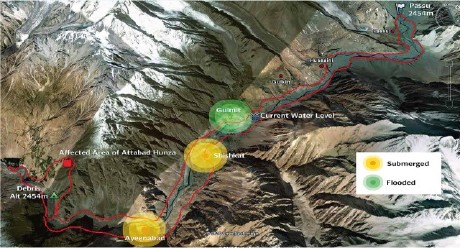
According to reports, landslides triggered by torrential rains cut off Gilgit-Baltistan from the rest of the country due to road blocks on at least four points near the Kohistan and Chilas areas. Tuesday’s landslide occurred at exactly the same point where the original avalanche blocked the Hunza River in January, creating the artificial lake that has inundated several villages upstream. Wazir Baig, along with deputy commissioner Hunza, was inspecting relief work at the site when heavy rock fall and boulders shook the area and struck the Attabad Lake, threatening a possible overflow within a few days time.
Authorities have warned that a rupture in the barrier could submerge at least 36 villages downstream, including Sarad and Mayon in the surrounding Nagar Tehsil, and as far as Kohistan and Chilas. People have said that government officials alerted various villages downstream, making evacuation announcements through loudspeakers in mosques. The impending flash flood is threatening nearly 18,000 living people downhill, possibly impacting areas all the way to Tarbela Dam…
Meanwhile, DCOs of Kohistan, Batagram, Hazara, Manshera, Abbotabad and Haripur districts also met on Tuesday to review possible complications arising from the dangerous situation. About 25 feet short of the 30 meter spillway dug by the Army, the Attabad Lake is likely to cross the barrier by May 26. Hazara Division stands to lose worst of all, while countless bridges constructed over the river Sindh were equally at risk, reported a news agency.
“The resulting chain reaction may also damage installations on the Indus River of which the Hunza River is a tributary,†the head of the flood forecasting division of the Pakistan Meteorological Office, Hazrat Mir, was quoted as saying in a report by IRIN, United Nations. Official statistics report that the lake’s current water level was at 348.6 feet while the inflow recorded on Tuesday was 3.8 feet. The length of the lake expanded beyond 28 kilometers.
I have been looking for information on exactly what is happening and why, because knowledge itself becomes a casualty in many disasters, and that itself has been difficult to come by. I am grateful to ATP reader Rehan Farooqi for alerting me to the website of Prof. David Petley of Durham University who has been keeping a much closer eye on this than I have and whose website is worth a visit for anyone wishing to understand what is happening here.
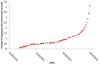 This graph, for example, shows just how quickly the seepage has been increasing since the January landslide, and how the seepage has increase exponentially with the warmer temperatures and recently (especially since now we have a fourth seepage point).
On May 12, Prof. Petley posted this new image from NASA – on deciphering which he has worked – which captures the Hunza River on May 2, 2010 and on which the outline shows the growth in the lake area since mid-March 2010 (click on image for the NASA page with commentary and larger image. Click here for further commentary from prof. Petley on his website).
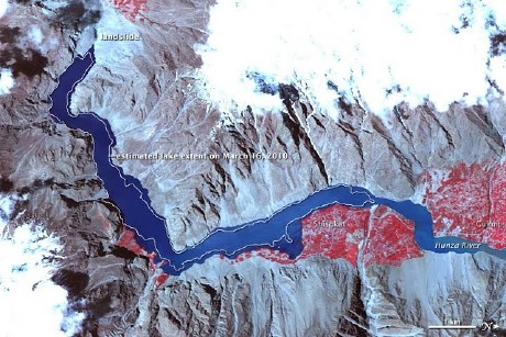
The commentary on this GIS image is instructive in understanding what has been happening:
On January 4, 2010, a landslide dammed the Hunza River in northern Pakistan, creating a lake that threatened to overflow its earthen dam and flood downstream communities. By mid-March 2010, the lake was 7 miles (10 kilometers) long. By early May, the lake had expanded well beyond its mid-March extent. As spring progressed, warmer temperatures began melting snow, which raised the rate of inflow to the lake.
The Advanced Spaceborne Thermal Emission and Reflection Radiometer (ASTER) on NASA’s Terra satellite captured this false-color image of the landslide lake on the Hunza River on May 2, 2010. Blue indicates water, red indicates vegetation, and shades of beige and gray indicate bare rock. The approximate extent of the lake on March 16, 2010, appears as a white outline. This image has been rotated, so north is to the right.
The river-blocking landslide appears near the upper left corner of this image. Next to the landslide, water levels have risen compared to their mid-March extents, and higher water is evident along the entire lake. In mid-March, north of the landslide lake, the Hunza River was a narrow tributary. In this scene, however, the water body is swollen well past the previous lake extent.
Compared to the largely barren slopes nearby, low, broad plains along the river support abundant vegetation (red in this type of image) associated with settlements. Video footage of settlements along the rapidly growing landslide lake, however, shows partially submerged trees and homes, as well as residents demolishing their homes to salvage building materials.


let us put this in true Pakistani perspective..
“people have been displaced in a region ‘somewhere’ north of Pakistan.. no body has been killed .. check out dramatic videos on youtube.. ”
i don’t see how this is a “crisis” .. until people are actually killed.. i am too preoccupied with my daily problems ..
This issue could have been handled more safely and in a much better way had it been looked into 4 months back…./As usual we were too concnerned about petty issues at that time. Sania Shoaib wedding and wheter she is our bhabi was of a major concern to us than this clamity…All major news channels were provided reports and videos but nobody listened. Sorry to say but even this site should have posted this article atleast 3 months back…
Thanks for such an informative post.
I wonder no one talked about its effects on Tarbela Dam. There got to be some.
http://www.nation.com.pk/pakistan-news-newspaper-d aily-english-online//Politics/19-May-2010/Govts-la xity-imperils-locals-lives-properties
Govt’s laxity imperils locals’ lives, properties
By MAQSOOD TIRMIZI
ISLAMABAD – Despite the report of Geological Survey of Pakistan (GSP) regarding terrain movement in Hunza Valley presented almost eight months before, the criminal negligence on the part of government while deserting the recommendations of the report has put the lives and properties of the local people at stake.
In the report ‘Causative Mechanisms of Terrain Movement in Hunza Valley’ submitted in September 2009 and also available with TheNation, the GSP has declared the major portion of eastern part of Atta Abad as highly hazard area while it was informed in the report that the area is bounded by half-length of Barali Shoe Nala crossing the terraces. The line of high hazard is extended parallel to the terraces to the Batur Kashi Nala and follows the Nala downside.
The area is under threat from multi-direction. On one side huge boulders of room size are lying loosely at the back slopes and most of them have moved from their original location because of the slope condition, any movement in the slope or an earthquake of magnitude of 4.5 or greater scale may roll down the boulders and hit the population”, the report warned. It maintained that the toe of terraces is creeping and displacements of terraces are the result of this weak toe because the rocks are highly sheared, fractured and jointed.
This part has a potential to slide down in the form of a rock avalanche and block the river. During investigation, the geological evidence of the same kind of threatened river blockage has been identified at 1.2km downstream at village Sarat. A landslide is present at the eastern margins of the area and material is falling into the river and it is further enhancing the triggering factors in the area, the GSP report warned.
It further recommended that the high hazard area should be evacuated immediately and the affected families should be compensated in the form of alternative lands or other arrangements while the boulders loosely lying on the backslope should be safely brought down using the techniques of control blasting.
“Poor drainage in the terraces should be managed into proper drainage and water should be diverted from infiltrating into cracks and loose overburden. It is not possible to fill all the cracks present in the area but nevertheless an effort should be made to fill and seal some cracks using the plastic sheets, starting from the terraces and moving upward into the backslopes”, the report recommended. It also added that it will help decrease the slope failure to some extent in the area where the slip circles are not deep while the slope conditions in the high hazard area and surroundings should be monitored in the snow melt or rainy seasons.
It merits mentioning here that on the request of National Disaster Management Authority, the study of terrain causing cracks in the houses pitched on the mountain slope in the village Atta Abad was carried out from August 9 to August 15, 2009 by the GSP personnel. The GSP was requested to investigate the causes for development of these cracks and suggest some remedial measures for the control and minimisation of the slide effects.
http://www.nation.com.pk/pakistan-news-newspaper-d aily-english-online//Politics/19-May-2010/Govts-la xity-imperils-locals-lives-properties
Being my self from Hunza, it very hard and painful to see my heaven sinking infront of my eyes. To many people , this might seems a recent thing as media is covering it now.Its been 5 months since the calamity has hit the area, more than 150 days have gone and still authorities are unable to release water from the lake. Infact they have failed to make the spill way and left the area to it fate, waiting the water level to rise and top over the blocade. What this means is , they have left the upstream villages to sink , because untill the water will reach the spill way , the areas and homes which are comparatively higher and not effected yet will submerge. What a failure and what an irresponsible reaction towards the poor poeple of Gilgit Baltistan who have always been segregated and denied the basic rights. On the otherhand the inefficient and lame provisional government comes occasionally on TV to deliver irresponsle coments. GOVERNMENT HAS FAILED. ONLY SOME NGOs and local volunteer are playing a role of back bone. The sole responsibility goes to the government of Pakistan. In september 2009 and november 2009 two geological reports by different NGOs have mentioned the risk of possile land slide and demanded the immedirte what so ever action but as usual no one is ready to listen.