Adil Najam
(Editors note: We are reposting this because ATP believes that this issue needs and deserves much more public attention than it has recieved).
For the last many days now I have been following the news from Attabad and Hunza region. The news has not been good. To get a sense of the magnitude of what is happening here, just take a look at this recent video of a landslide in Hunza:
In fact, I would argue that the Hunza landslide is the single worst news confronting Pakistan today amongst all the bad news we are bombarded with. Worse than the news of a wannabe terrorist in New York, worse than TV news-anchor scandals, worse than Presidential pardons for Rahman Malik, and certainly worse than the fuss in a teacup over some Facebook page. What has been happening with the Hunza landslide is utterly catastrophic in terms of its natural as well as human impacts. This is a real calamity with real human victims and one that has already put the lives and livelihoods of not dozens but thousands of people at real risk today and will do so into the future.
I have been following the events up in Attabad and the Hunza region with growing trepidation – constantly hoping that maybe things would subside or get better or someone will figure out what to do. They have not. In fairness, the hope was a false and unrealistic one since very little can be done at this stage beyond better management for those multitudes who have been displaced in this catastrophe.
Here is an early glimpse of what this means to the lives of thousands of real people.
And this, all indications suggest, is just the beginning. As so often happens in disasters such as this, things are likely to get a lot more worse before they get any better. This news report in The Express Tribune explains how the lake is expected to breach its barrier by May 26:
As another landslide plunged into Attabad Lake on Tuesday, the Hazara division is expected to bear the worst brunt of an imminently approaching breach of the massive artificial lake.
Officials suspended boat service, the only current form of travelling downstream across the blocked Karakoram Highway (KKH), citing unsafe conditions. “We will start helicopter service in place of boat service,†said Wazir Baig, Speaker Gilgit-Baltistan assembly to The Express Tribune. “You see, landslides are constantly occurring and we can’t afford that people further suffer due to these kinds of incidents,†he added.
According to reports, landslides triggered by torrential rains cut off Gilgit-Baltistan from the rest of the country due to road blocks on at least four points near the Kohistan and Chilas areas. Tuesday’s landslide occurred at exactly the same point where the original avalanche blocked the Hunza River in January, creating the artificial lake that has inundated several villages upstream. Wazir Baig, along with deputy commissioner Hunza, was inspecting relief work at the site when heavy rock fall and boulders shook the area and struck the Attabad Lake, threatening a possible overflow within a few days time.
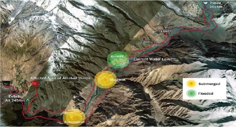
Authorities have warned that a rupture in the barrier could submerge at least 36 villages downstream, including Sarad and Mayon in the surrounding Nagar Tehsil, and as far as Kohistan and Chilas. People have said that government officials alerted various villages downstream, making evacuation announcements through loudspeakers in mosques. The impending flash flood is threatening nearly 18,000 living people downhill, possibly impacting areas all the way to Tarbela Dam…
Meanwhile, DCOs of Kohistan, Batagram, Hazara, Manshera, Abbotabad and Haripur districts also met on Tuesday to review possible complications arising from the dangerous situation. About 25 feet short of the 30 meter spillway dug by the Army, the Attabad Lake is likely to cross the barrier by May 26. Hazara Division stands to lose worst of all, while countless bridges constructed over the river Sindh were equally at risk, reported a news agency.
“The resulting chain reaction may also damage installations on the Indus River of which the Hunza River is a tributary,†the head of the flood forecasting division of the Pakistan Meteorological Office, Hazrat Mir, was quoted as saying in a report by IRIN, United Nations. Official statistics report that the lake’s current water level was at 348.6 feet while the inflow recorded on Tuesday was 3.8 feet. The length of the lake expanded beyond 28 kilometers.
I have been looking for information on exactly what is happening and why, because knowledge itself becomes a casualty in many disasters, and that itself has been difficult to come by. I am grateful to ATP reader Rehan Farooqi for alerting me to the website of Prof. David Petley of Durham University who has been keeping a much closer eye on this than I have and whose website is worth a visit for anyone wishing to understand what is happening here.
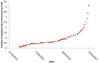 This graph, for example, shows just how quickly the seepage has been increasing since the January landslide, and how the seepage has increase exponentially with the warmer temperatures and recently (especially since now we have a fourth seepage point).
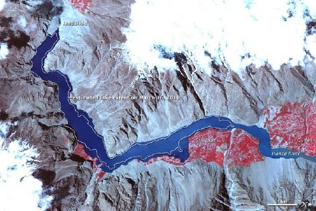
On May 12, Prof. Petley posted this new image from NASA – on deciphering which he has worked – which captures the Hunza River on May 2, 2010 and on which the outline shows the growth in the lake area since mid-March 2010 (click on image for the NASA page with commentary and larger image. Click here for further commentary from prof. Petley on his website).
The commentary on this GIS image is instructive in understanding what has been happening:
On January 4, 2010, a landslide dammed the Hunza River in northern Pakistan, creating a lake that threatened to overflow its earthen dam and flood downstream communities. By mid-March 2010, the lake was 7 miles (10 kilometers) long. By early May, the lake had expanded well beyond its mid-March extent. As spring progressed, warmer temperatures began melting snow, which raised the rate of inflow to the lake.
The Advanced Spaceborne Thermal Emission and Reflection Radiometer (ASTER) on NASA’s Terra satellite captured this false-color image of the landslide lake on the Hunza River on May 2, 2010. Blue indicates water, red indicates vegetation, and shades of beige and gray indicate bare rock. The approximate extent of the lake on March 16, 2010, appears as a white outline. This image has been rotated, so north is to the right.
The river-blocking landslide appears near the upper left corner of this image. Next to the landslide, water levels have risen compared to their mid-March extents, and higher water is evident along the entire lake. In mid-March, north of the landslide lake, the Hunza River was a narrow tributary. In this scene, however, the water body is swollen well past the previous lake extent.
Compared to the largely barren slopes nearby, low, broad plains along the river support abundant vegetation (red in this type of image) associated with settlements. Video footage of settlements along the rapidly growing landslide lake, however, shows partially submerged trees and homes, as well as residents demolishing their homes to salvage building materials.


The hint of this terpene fuse – botanical derived terpenes is at bottom unclutter and fundamental, not too tireless but mollify noticeable in the best way. It blends smoothly and adds a much better flavor profile without overpowering all things else. Flush a slight amount makes a contradistinction, which says a lot around the quality. The packaging was healthy, shipping was connected, and the mainly happening felt reliable. Unquestionably sound product and everyone I’d cheerfully uncalled-for again.
People from hazara must read this
http://pakistanall.blogspot.com/2011/08/is-formati on-of-new-provinces-is.html
I want share with you people a website I found on google which actually pictures the whole story with time line, it open my eyes if authorities were able to cop the matter timely, this disaster could avoid to be happened…
http://ebuzzs.blogspot.com/2010/06/facts-of-attaba d-lake-hunza-time-line.html
Another report about Pakistan’s water system falling apart
http://www.theglobeandmail.com/news/world/thirsty- pakistan-gasps-for-water-solutions/article1608905/