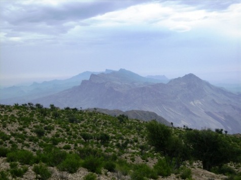
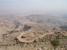
Do you know there is a place in Sindh where it snows in winter? Yes, there is one such place and it is called Gorakh Hill . It is located in Dadu District and has an altitude of 5500 ft. It is the highest place in the Kirthar range of hills (reachable by road) which also forms the provincial boundary between Sindh (Dadu) and Balochistan (Khuzdar) as a jagged backbone. The highest peak in Sindh is also located in the Kirthar range and is called ‘dog’s grave’ and has an altitude of 2174 m (7133 ft). Following is a breath taking view of Gorakh Hill. Photo credits belong to [2] below.
How to Reach There:
From Dadu city the top of Gorakh Hill is at a distance of 93 km. To reach Gorakh, one starts going west from Dadu. At kilometer marker 17 from Dadu, is a place called Johi which is a ‘tehseel’ of Dadu district.
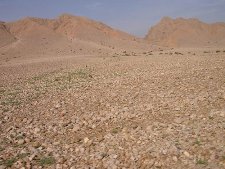
At kilometer marker 39 from Dadu is a village called Wahi Pandi which forms the base camp of Gorakh Hill. Wahi Pandi is a decent size village with a population of approximately 20,000.
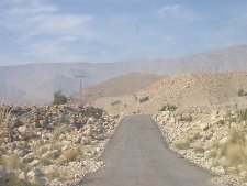
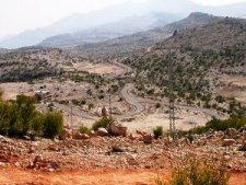
The photo to the left below shows landscape near Wahi Pandi. The photo to the right below shows a glimpse of single track road to Gorakh Hill
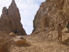
After Wahi Pandi the road gains altitude fast. At kilometer marker 53, the road enters a pass called the Yaro Pass. In Sindhi it is called the ‘Yaro saain jo lak’. Yaro pass is located at an altitude of approximately 2500 ft. At kilometer marker 76, the road enters yet another pass. This one is called the Khanwal Pass and it is 4 km long.
The photo to the left below shows road through Yaro Pass. The photo to the right below shows the starting point of Khanwal Pass

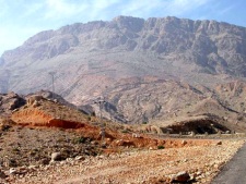
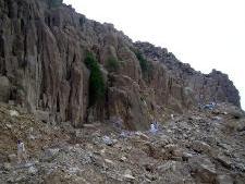
The lower end of Khanwal Pass is at approximately 3000 ft above sea level while the higher end of the pass is at approximately 5000 ft altitude. From the top of Khanwal Pass to the top of Gorakh Hill is a distance of another 13 km. (kilometer marker 93 from Dadu).
The photos below show different views of Khanwal Pass.
Coming from Karachi, there is a shorter route to Johi. A road from Sehwan Sharif on Indus Highway (N55) branches off to Johi at a distance of 40 km. This way you can bypass the city of Dadu and the route is 20 km shorter.
Accommodation at the Top:
There is a small rest house available at the top of Gorakh Hill but be prepared to do camping outside. According to Reference [1] below:
Out of the two rooms, only one can be used by guests, as the other one is being used as a store room. While the rest house is wired up, there was no electricity, probably due to heavy rains I presume. However, there is a back-up generator in working condition, but no water, so remember take a good amount of with you
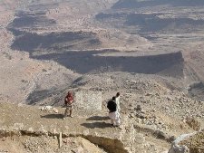
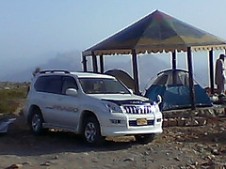
The photos below are courtesy of my friend Shabbir Ali Bijarani and show his camping trip to Gorakh Hill

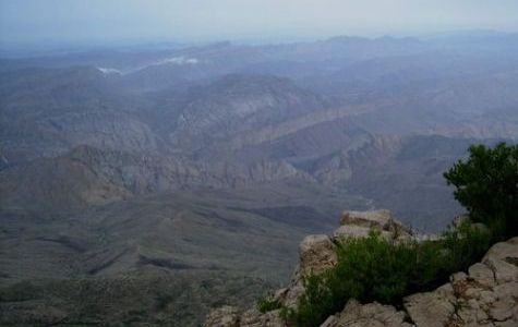
Gorakh Hill top gives a vast unhindered views of the Sindh and Balochistan landscape. According to [1]:
The sunrise is definitely worth viewing here. As the early rays of the sun hit the top one can see the gradual illumination of the beautiful valley of Wahi Pandi towards the east, while the Sindh-Baluchistan border lies visible towards the west.
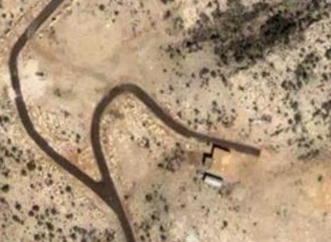
Satellite Images of Gorakh Hill:
The first image shows the road-end at the top of the Gorakh Hill as well as location of a small rest house.
The image below shows the location of Gorakh Hill by red arrow. The white line to the left is the Sindh-Balochistan border. Also note the winding road leading to Gorakh Hill

History of Development:
 Sometimes back in 1998, it was decided to make Gorakh Hill a resort for tourists at par with other hill stations of Pakistan located in North-Western Pakistan. The hill resort project included development of a waterfall, cable chair lift from the Gorakh hill to the Chokor hill, 10-beded hospital, water filter plant, security check post and a race course.
According to [4],
Despite passage of eight years and expenditure of more than Rs 200 million, the fate of the Gorakh Hill station project still hangs in the balance because of indifference of the government. The PC-1 of the project was revised and an amount of Rs 198.269 million was released on Feb 24, 2004. The funds were meant for constructing a road from Wahi Pandi to Gorakh hill at a cost of Rs 86.353 million, development of water supply scheme at the cost of Rs 34.636 million and purchasing vehicles and other equipment at a cost of Rs 8 million
Communications at the Top:
There are neither any land lines for telephone nor a mobile service available at Gorakh Hill. However, Pakistan Telecommunication Limited (PTCL)’s wireless service called the V-PTCL Wireless works at Gorakh Hill. Reference [1] below.
Weather:
In summers the day time temperature at Gorakh Hill reaches 25C but at night a drop of 20C to 5C is not unusual. Gorakh Hill gets occasional snowfall during winters too.
ATP’s Related Post on Another Tourist Spot in Kirthars:
Toshangi Gorge: The Grand Canyon of Sindh
References and Photo Credits:
[1] Gorakh Hill Station by Umair Ahmed Shaikh of 4×4 Offroaders Club, Karachi
[2] Gorakh Hill Photo by umashah79 here.
[3] Gorakh Hill Photo by ahashmi here.
[4] Gorakh Hill Project in doldrums
[5] Rakaposhi Hiking Club, Nawabshah
[6] www.googleearth.com
[7] Shabbir Ali Bijarani’s photos here


Meengla and all. i’ve added a map showing location of Dg’s grave at Toshangi Gorge post. Take a look at:
http://pakistaniat.com/2008/05/23/toshangi-gorge-t he-grand-canyon-of-sindh/
The map is towards the end of the post
Owais, thanks again. I wonder if you can share the map which shows ‘Dog’s Grave’ peak’s location?
Also, here is some latest news about Gorakh Hill Station. Looks like people are determined to complete this project despite criminal negligence and corruption.
—————————————
http://www.dawn.com/2008/05/26/local18.htm
DADU: Rain, winds disrupt Gorakh Festival
By Qurban Ali Khushik
DADU, May 25: Heavy rain and strong winds with no arrangement made for water and electricity, forced the organisers of the Gorakh Festival to end the much-hyped programme even before it started on Saturday.
The festival organised by Village Shadabad and ActionAid Pakistan was to be held on Saturday and Sunday but the organisers could hold only a musical programme.
Scores of writers, intellectuals and media persons braved scorching heat and a tortuous journey to reach the hill. They made a stopover in Johi for a few hours and then resumed journey to a camp at the foot of the hill.
Some of them climbed the hill on foot while others used four-by-four vehicles despite strong winds and heavy rain and many of them managed to make it to the top of the hill station, located 450 kilometres to the north of Karachi and 100 km to the west of Dadu.
The area has cold even when the plans of Sindh are sizzling hot, which makes it an attractive tourist destination in the province.
The 54-kilometere carpeted road from Wahi Pandhi to the foot of the hill had potholes and breaches at a number of places while a stretch of six km was yet to be carpeted. Work on many small bridges and culverts, which were supposed to drain out rainwater, appeared to have stopped. When the wary visitors somehow managed to reach the top they were told their ordeal had not ended yet as the water supply scheme from Hingan Spring to the hill station was still incomplete and there were no alternate arrangements for water.
Many government departments and NGOs could not set up their stalls and a large number of high-profile guests, including Sindh Minister for Tourism and Culture Sassui Palijo, senior officers of her ministry, Gorakh Hill Station Authority and district administration, failed to attend the festival.
Former speaker of Sindh Assembly Hussain Haroon was the only main guest who made it to the top of the hill but he, too, had to cut short his visit and return after a few hours due to bad weather.
Mr Haroon called the hill station the best tourism spot not only of the province but of the country and said that it could prove to be a good tourist point for Karachiites.
Nasir Panhwar, a visitor, demanded early completion of Gorakh Hill Station project and said that the officials had completed it on papers but in reality nothing had been done on ground.
The president of Village Shadabad, who was organiser of the festival, apologised to visitors for lack of facilities and renowned writer Zulifiqar Ali Siyal demanded that the federal and provincial governments should pay special attention to the tourist spot.
Renowned archaeologist Syed Hakim Ali Shah urged the prime minister to grant special funds for the hill station and order an enquiry into the alleged misappropriation of funds for its development.
The heavy rains forced more than half of the visitors to return late on Saturday while the rest rushed back home early in the morning on Sunday, leaving behind scores of others who were reportedly caught up in flash floods.
Gorakh Hill Station project was approved in August 1998 with an estimated cost of Rs45.252 million. Initially, Rs15.155 million were allocated for 32-km long road, Rs11.375 million for bridges, Rs17.409 million for water supply scheme and Rs1.313 million for setting up police posts along the road leading to the hill.
The cost was later revised upwards to Rs198.269 million.
Meengla you are correct. ‘dog’s grave’ point is the highest place (It is a mountain peak) in Sindh which is reachable by foot or by camel. Gorakh hill is the highest point achievable by road and hopefully soon by a paved road all the way.
The map that I have shows highest point in Sindh (Dog’s Grave) at a height of 2174 m (7133 feet) and just 20-30 kilometers south of Dog’s grave is the second highest peak of Sindh at a heiht of 2171 m (7122 ft). The name of this second peak is unknown to me.
Corrections to my last post:’Kutte Ji Kabar’ is not approx. 8000 feet; from my Google searches, it is around 6800+ feet. My apologies. But I do recall finding in the atlas a peak just along Sindh-Baluchistan border in very northern part of Kirthar Range with elevation approaching 8000 feet.
Anyway, let’s keep Gorakh Hill Station project on track at least by discussing it…
Great post Owais Mughal. Thanks a lot.
Umair A. Shaikh was the first as far as I know who took a trip to Gorakh Hill Station and actually documented his experience, backed by some great pictures. I started a thread in Offroadpakistan.com forum about Gorakh in late 2005 and the thread attracted the highest ‘views’ in that forum.
But, lately, I have been disappointed because most recent news point toward the usual ‘corruption’ and mismanagement leading to the delays.
Hopefully, with a change in govt., the project will jump start.
http://offroadpakistan.com/forums/viewtopic.php?id =111
is the Forum on offroadpakistan.com where much info is available. I think law n order situation/problem may be exaggerated but I am not sure.
Oh, Gorakh Hill is not the highest point in Sindh’s Kirthar Range. I think ‘Kutte Ji Kabar’ (Dog’s Grave) is the highest peak and it may be close to 8000 feet high–much higher than Gorakh Hill though the latter is better suited for a Hill Station because of terrain.
Since my younger years when an uncle gifted me an atlas by the Geological Society of Pakistan I have studied Sindh’s mountains and have dreamed about a Hill Station in Sindh. The Stations don’t have to be lush green like Murree but the cool weather and majestic vistas are certainly great attractions. Every other region of Pakistan has at least one Hill Station; it is about time Sindh gets one too.
The economy of Sindh and Pakistan can greatly benefit from Gorakh Hill Station and similar projects.
Can anyone in this Forum have an influence over powers-be in Pakistan to keep the Gorakh Hill Station project on track?
Again, Owais, your effort is much appreciated.