After traveling from Karachi to Torkham by highway N5 (part I, II, III, IV and V) we will now branch our journey westward and travel Sukkur to Quetta portion by national highway N65. Just like our series on N5, we will try to cover small towns in more detail as compared to larger cities (Quetta and Sukkur) which are relatively more famous and better known.
Let us start our journey with a route map. Main milestones, landmarks and towns enroute have been marked with rectangles in the map.
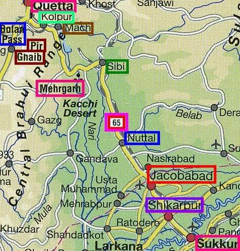
Sukkur (0 km)
We will start our journey from Sukkur which is the zero-point of Highway N65. Sukkur is located on the West Bank of River Indus. From N5, one can cross over from Rohri to Sukkur via Sukkur Barrage or the old Lansdowne Bridge which I believe is open for light traffic only (no trucks or buses allowed).
Sukkur is Sindh’s 3rd largest and Pakistan’s 14th largest city. According to 1998 census, population of Sukkur was 329176.
At ATP we have also covered Sukkur briefly in following two posts:
(i) Meenar-e-Masoomi, and
(ii) Clock Towers of Pakistan
Lakhi (24 km)
Lakhi is a small town on N65. A road from here goes to Habibkot which is railway junction to Larkana. The road from Lakhi crosses Habibkot and goes to a town called Guheja on the famous Indus Highway (N55).
Shikarpur (37 km)
Shikarpur is Sindh’s 8th largest and Pakistan’s 35th largest city. Population according to 1998 census was 133259. Shikarpur is famous for the pickle industry here. Shikarpuri achaar (pickles) are famous all over Pakistan.
Shikarpur is also famous for Soomro family whose members have always played a key role in Pakistan’s politics. In pre-partition days, Khan Bahadur Allah Bux Soomro was a key politician of Sindh. He got elected as Chief Minister of Sindh but was assassinated while going in his horse driven carriage in Shikarpur on 14 May 1944. Sardar Maula Bux Soomro was the Central Minister for Rehabilitation in 1957. His son Illahi Bux Soomro was a senator and his grandson Mohamed Mian Soomro had been the Chairman Senate. A rare collection of Soomro family photos can be seen here, courtesy of Dr. Ghulam Nabi Kazi.
The Insight Guide to Pakistan gives Shikarpur’s introduction in following words:
Shikarpur is surrounded by rich farmlands and mango orchards. Its gardens had once earned it the name of ‘Paris of Sindh’, and the assiduousness of its traders and merchants commercial respect from Rangoon to St. Petersburg.
The wealth of the town’s trading class manifested itself in mansions adorned with tastefully carved wooden facades, now fast disappearing to reapper in rich houses in Lahore and Karachi.
A glimpse of the rich architecture in Shikarpur is visible from the photo to the right above. The signboard in Sindhi reads Government Commercial College, Shikarpur.
The photo to the left shows main Shikarpur bazar in 1850s. Since the trading class was almost entirely Hindu, the city was divested of its upper class in 1947. There is only one garden left in Shikarpur, the Shahi Bagh (Royal Garden).
Shikarpur on N65 is also a road junction where N65 crosses with the famous Indus Highway (N55). Another road from Shikarpur goes to Garhi Yaseen and onwards to Rato Dero, which will be a major intesection on Pakistan Motorway Network.
Sultan Kot (51 km)
Humayun (58 km)
A small road from Humayun branches off from N65 and goes to the city of Kandhkot located on Indus Highway N55.
Jacobabad (79 km)
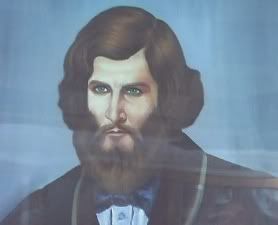 Jacobabad is named after General John Jacob (1812-1858) (photo to the right), of the Scinde Irregular Horse. It is said that he was one of those eccentric and far larger than life Victorians. Jacobabad was his headquarters and it still bears his mark. The Insight Guide of Pakistan describes it in following words:
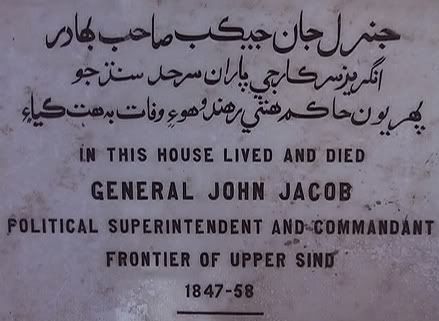
The photo to the left shows the cemetery where General John Jacob is buried.
The Roads he laid out, the house where he lived and his dovecote all bear his mark. The tomb where they laid him (mourners came from miles around and the sound of women tearing their hair and men wailing was “indescribable”) is still a shrine of sorts where they burn oil lamps and sometimes even pray for intersection with God.
The town is also the location of a 5-metre (16-ft) high pyramid – the grave of Jacob’s horse.
Jacob’s Clock:
Housed in the very bungalow where Jacob lived and worked is Jacob’s Clock, every singly part of which was designed and assembled John Jacob himself. This superb piece of engineering crafted entirely from brass (now in a protective timber and glass case), shows the month, day of the week, date, phases of the moon and hours of the day. Even after the passage of a century and a half when Jacob would have first stood back to admire his handiwork, it keeps excellent time. With the house still serving as the residence of the Deputy Commissioner, permission is required to see the clock.
 Jacobabad is Sindh’s 7th largest and Pakistan’s 35th largest city. Population according to 1998 census was 137733. Jacobabad is also a Railway junction on Pakistan’s Railway network with tracks branching off to Kashmore and Dera Ghazi Khan.
Victoria Tower Jacobabad:
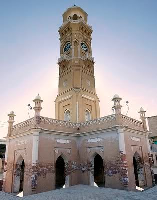 There is an inscription on a wall of this historical monument ,which says:
This Tower was erected by the subscriptions of the Zemindars and other inhabitants of the frontier district, the Hindu panchayat and municipality of Jacobabad and the district local funi board in commemoration of the jubilee of then Queen-Empress. WH.CH was celebrated at Jacobabad on the 16th of February 1887. The design was made and stone work executed under the superintendence of Colonel S.S.Jacob, Executive engineer of the Jeypore State and cousin of the late General John Jacob,C.B. The work was supervised by Rao Bahaudur G.R. Tilaka .L.C.E .Executive Engineer, and D.Herbert , ESO assistant engineer ,P.W.D. The building was opened on the 21st November 1888, by Miss Pritchard, daughter of C.B. Pritchard ,Esq, C.S. C.S.I commissioner of Sind, who presided on the occasion.
R Giles Deputy Commissioner U.S.E
Jacobabad is notable as a major grain center. The area around Jacobabad is also of interest since it is the site of a large heronry. During the September-October breeding season incredible numbers of night herons and egrets stalk about the town and perch on houses and trees
Jacobabad is also a road junction where roads from N65 branch off to the towns of Rato-Dero and Larkana to the south east and to Kandhkot in the North east.
Provincial Boundary of Sindh and Baluchistan:
The provincial boundary of Sindh and Bluchistan is located between the city of Jacobabad and the town of Jhatpat. I am not able to research the exact kilometer marker of this provincial boundary except that it is located between Jacobabad and Jhatpat. Help from our readers is sought here.
Jhatpat (95 km)
Jhatpat is a small twon located in the wild and desolate lanscape of the Pat and Kacchi desert. The shimmering heat in summer months produces incredible mirages.
Jhatpat is a road juction where roads from N65 branch off to go to Nasirabad in North and to Usta Mohammad and Shahdadpur to the south.
Dera Murad Jamali (116 km)
The place is hometown to ex Prime Minister of Pakistan, Mir Zafarullah Khan Jamali. Earlier on this town was used to be called ‘Temple Dera’ named after Sir Richard Carnac Temple (1850-1931) who was once stationed here.
According to 1998 census, population of Dera Murad Jamali was 37766.
A small road from Dera Murad Jamali off of N65 goes to Bagad and onwards to Sui in Baluchistan.
Nuttal (145 km)
This place is named after British Army Brigadier-General T. Nuttal who was once stationed here. T. Nuttal is famous for leading the cavalry in the famous battle of Maiwind on July 4, 1880.
Roads from Nuttal branch off from N65 and go to the towns of Chhatr, Lahri in North and to Abad in the south.
Bellpat (169 km)
Small roads from Bellpat off of N65 branch off to Lahri in the north and to Bhag and Mahmud Aulia in the South West.
Sibi (237.6 km)
As N65 gets near Sibi, the Brahui mountains come into view in the distant horizon. Sibi town is famous for its old mud fort and the highest simmer temperatures ever recorded on the sub-continent.
Sibi’s annual horse and cattle fair, is the most colorful in South-West Pakistan. It is held every february and draws tribesmen from all over Baluchistan. Quaid-e-Azam Mohammad Ali Jinnah also attended this ‘Sibi Mela’ before Pakistan came into being.
Sibi was occupied by Mahmud of Ghazni in 1005. Five centuries later, Ameer Chakar Rind, who united the Baluch tribes, defeated the ruler of the Sammah Dynasty at Sibi.
Amir Chakar Rind‘s 16th century fort still stands near the town which was briefly occupied by the British in 1841. But it was not unitl 1879 that they established a permanent presence in the town, where Sir Robert Sandeman negotiated with the Marri and Bugti tribesmen during his pacification of the area.
According to 1998 census, population of Sibi was 48219.
Dadhar (259 km)
Mehr Garh Archaeological Site (Older than Mesopotamia):
Approximately 10 km north west of Dadhar on N65 and then 8 km south west of N65, is Mehr Garh, an early pre-Indus Civilization Archaeological Site. Excavated by French archaeological team, there are shards everywhere, some in piles, some scattered around.
Dating from between 6000-3000 BC, this Neolithic settlement is the earliest so far found on the sub-continent. It depicts a remarkably well-advanced society which was among the first to domesticate the water buffalo. For 6000 years ago this semi-desert was a wetland with many lakes and marshes. The people roamed the now vanished grasslands hunting feral sheep and swamp deer, a species long since extinct.
Mehr Garh was a very well ordered city with streets laid out in grids and two or three storeyed houses constructed with cut stone and brick. By 6000 BC the city was the size of 30 acres with a probably population of 3000.
Although one has to go to the Quetta Museum and the National Museum in Karachi to see collections of excavated artefacts, it is amazing to come to here and ponder the fact that this is the site of the earliest urban culture known to Man.
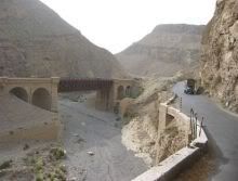
Kundlani (278 km)
Kundlani is approximately the starting point of famous Bolan Pass. Ninety six kilometers long, the narrow Bolan Pass is more dramatic and spectacular than the better known Khyber Pass to the north., with giddying views of the palm-studded valley floor, all visible from the highway N65.
The British negotiated with the Khan of Kalat and in 1883 were given a permanent lease to the Bolan Pass. Four years later the whole of Baluchistan was in British hand. So much was(is) the strategic importance of Bolan Pass.
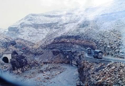
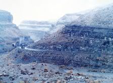
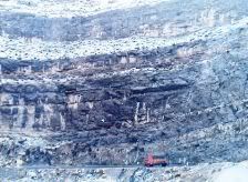
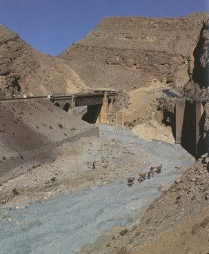
Photos of N65 from December 1993:
With a group of University friends, I took a tour of Quetta in December of 1993. These photos were taken from an open train window (Bolan Mail) and show N65 running parallel with the rail track. In one of the smaller photos, note the size of goods truck as compared to the Bolan Pass mountain. These photos were already 15 years old before I digitized them, hence the lower color quality.
Pir Ghaib (Direction Marker on N65 at Km 314):
At km marker 314 on N65, a sign on the left of the road points to Pir Ghaib (The Invisible Saint). From the sign, Pir Ghain place is located 10 km south of N65. The trail leads off into a dry and barren landscape the color of sun-dried chaff. The trail passes a village called ‘Khajuri‘. After Khajuri the road seems to be headed directly towards a rock wall. As it approaches the wall, it climbs and ends at a solitary house. Beyond is a thick clump of shisham and date palms, a veritable oasis with the sound of falling water clearly heard above the cooing of doves. From the edge of the cliff to the right two waterfalls plunge 15 m (50 ft) over a rock wall covered with a great mass of bright brown and green lichens to the limpid pond below. Behind the house is the tree shaded tomb of Pir Ghaib with toy cradles hanging in the branches to acknowledge the supplication for sons being granted.
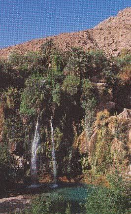 And beyond that is the source of the spring: a hole with the water gushing out. The insight guide to Pakistan gives the story of the Pir Ghaib in following words:
Legend relates that Pir Ghaib and his sister, the venerable Bibi Nani, arrived here to convert the local heathens in the early days of Islam. But the fire worshippers sent an army after the pious pair. IN the gorge of the Bolan, the siblings split; Bibi Nani went down the gorge (her purported tomb is under a bridge about 15 km downstream) while her brother fled into this arid landscape with the army in hot pursuit. At the head of the gorge, seeing that he was blocked by the rock wall, the saint prayed to almighty to be rescued. As is the wont of the Lord of all saints, He cleaved the rock to receive the holy man. And so he was known as Pir Ghaib – The Invisible Saint.
Local Hindus worshipo Pir Ghaib as Mahadev. But, long before the Bolan gorge had rung with vedic hymns or invocations of the Pir Ghaib, travellers and traders from the Indus Valley would have stopped at this spring sacred to their own gods on the first leg of their long journey to Mesopotamian marts. As the vedic God Shiva derives from an earlier Indus Valley diety, and as the 5000 year old goddess Nania evolves into Bibi Nani or Durga, so too did the Pir Ghain develop from an early Indus Valley god. But until the Indus script is understood we will not know which from this pantheon was celebrated for walking into rock walls.
The road to Pir Ghaib is a stony path. The trip is possible only with a light pick-up or a jeep. It is therefore best to return from Quetta or Mach with an appropriate vehicle. One way running time from Quetta to Pir Ghaib is about 100 minutes.
Mach (332 km)
The name ‘Mach’ means date palm in Baluchi. It is a sprawling, a bit untidybjumble of houses. But it is truly cosmopolitan, for here in the dusty bazaar one can hear Urdu, Punjabi, Seraiki, Brahui, Pushtu, Balochi and Sindhi. Lying at the very mouth of Bolan Pass, Mach is a busy railway station. Here all Quetta-bound trains are coupled with an extra banking locomotive in the rear. Yet they barely crawl up the winding pass, clanking and growling over the bridges, in and out of the tunnels with evocative names and magnificiant portals.
While travlling on N65, between the tiny stations of Dozan and Kolpur at the head of the pass, the old meter-gauge bridge piers and tunnels can still be seen right below the line.
Mach is also famous for a prison here. Many political prisoners have spent time here. Lollywood even made a movie called ‘Mach Jail’ on the topic.
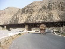
Kolpur (355 km)
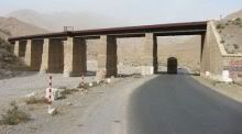
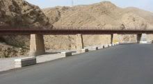
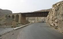
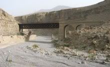
 Kolpur is located at an altitude of 1790m (5872 ft). The highway N65 passes through the Kolpur bazar with the village sprinkled to the west and beyond that is the railway station. The portal of the last tunnel before Quetta is just beyond Kolpur station and surely is the most impressive on this section. Photo to the left shows famous Elgin railway bridge in Bolan Pass as well as highway N65 towards the right. Also note a caravan of camels on the dry river bed.
Spezand (372 km)
With sprawling Quetta, Spezand is now almost a Quetta suburb. More than N65, Spezand is famous for the railway junction with the railroad branching off to distant Iran from here.
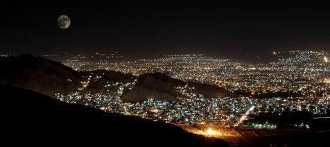
Quetta (385 km)
Quetta is the provincial capital of Baluchistan and also the largest city of the province. It is also the 9th largest city of Pakistan. According to 1998 census, population of Quetta was 560307.
We would like to cover this city in detail therefore we’ll end our journey on N65 here. ATP will cover Quetta and the places to visit there in near future. In the meantime following is a teaser photo of this beautiful city of Pakistan.
ATP’s Posts on Quetta:
1. An Old Roller of Quetta Municipality
2. Coexistence is Quetta
3. Amphibian Motorcycle in Quetta
4. When Moses Lost his papers in Quetta
ATP’s Posts on the Road Network of Pakistan:
1. Traveling on N5 – I: Karachi to Rohri: 483 km
2. Traveling on N5 – II: Rohri to Bahawalpur: 361 km
3. Traveling on N5 – III: Bahawalpur to Lahore: 417 km
4. Traveling on N5 – IV: Lahore to Rawalpindi: 272 km
5. Traveling on N5 – V: Rawalpindi to Torkham: 216 km
6. Friendship Tunnel, Kohat
7. RFID based E-Toll System on Pakistan Motorway
8. Peshawar-Islamabad Motorway M1 is inaugurated
9. Lyari Expressway inaugurated
10. GPS Automotive Navigation in Pakistan
References:
1. Map of Pakistan by Nelles Maps
2. Insight Guide to Pakistan by Discovery Channel
3. Spectrum Guide to Pakistan by Camerapix
4. Rare Maps of Pakistan by F.S. Aijazuddin
Photo Credits:
1. uMaIr
2. Dr. Ghulam Nabi Kazi
3. Agha Waseem
4. Mohammad Lateef
5. Photos of N65 after description of Mach are courtesy of Umar Marwat.


Sarfraz, thanks a lot for the information on new names of the cities/towns along N65. If you are in the area then do you know the flood situation? Especially how’s N65 and railway track doing? I know the railway track has been submerged and almost destroyed betweek Kot Sultan and Rojhan Jamali.
Corrections:-
Jhatpat is called Dera Allah Yar now.
Bellpat is Baktiarabad.
Ex PM Jamli’s home town is Rojhan Jamlai.
Boundary between Sind & Balochistan on N 65 is a water canal 5 km south of Dera Allh Yar.
Qasim, point taken on travel guide category. We do have a ‘travel’ category for now. Most of these posts can be searched under it. Take a look:
http://pakistaniat.com/category/travel/
Great writeup. so informative and pictures also good. thanks
Great writeup and pictures.
Always good that you mix posts like this and tu tara tara etc posts