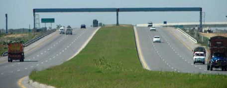
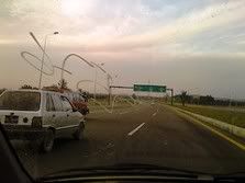
The 155 km long Motorway M1 between Islamabad and Peshawar in now open for traffic in its entirety. The 117 km portion of it got inaugurated on October 30, 2007.
M1‘s construction work was initially started in the year 1993 by a Turkish company Bayindar but it left the work incomplete in 1997. The contract was the re-awarded to a consortium called PMC-JV in 2003.
The speed limit on M1 is 120 kmph and it is completed at a cost of Rupees 16 bn.
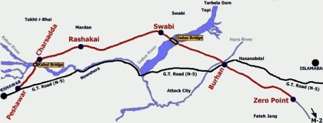
M1 has 9 interchanges at Fatehjang, Bhatar, Burhan, Rashaki, Swabi, Chachh (under construction), Charsadda, Northern Bypass and Ring road on N-5. There are 3 major bridges on Haro, Indus and Kabul rivers, 18 flyovers, 27 other bridges, 137 underpasses and 571 culverts. 10 services areas— five on the each side of the motorway— would be provided out of which, four mini service areas at km-4 and km-106 have been completed. Six main service areas at Haro bridge, Indus River and Kabul River will start functioning after some time as they are still under constructions

The proposed Pakistan Motorway project is approximately 3000 km long network of access controlled, signal free highways. With the inauguration of M1, 768 km of this network is now operational. Following is the complete list of motorway sections planned and operational in Pakistan.
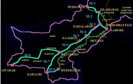
M1: Peshawar – Islamabad : 155 km (6 Lane, Access Controlled, Operational)
M2: Islamabad – Lahore: 367 km (6 Lane, Access Controlled, Operational)
M3: Pindi Bhattian – Faisalabad: 53 km (4 Lane, Access Controlled, Operational)
M4: Faisalabad – Multan: 243 km (proposed 4 Lane)
M5: Multan – Dera Ghazi Khan: 65 km (proposed 4 Lane)
M6: Dera Ghazi Khan – Rato Dero: 450 km (proposed 4 Lane)
M7: Rato Dero – Karachi: 303 km (proposed 2 Lane)
M8: Gawadar – Ratodero: 1072 km (under construction, 2 Lane road completed and operational)
M9: Karachi – Hyderabad: 136 km (4 Lane, Access Controlled, Operational, 6 Lanes planned)
M10: Karachi Northern Bypass: 57 km (6 Lane, Access Controlled, Operational)
Shahrah-e-Sanat Lahore- Sialkot: 101 km (under construction)
TOTAL : 3002 km
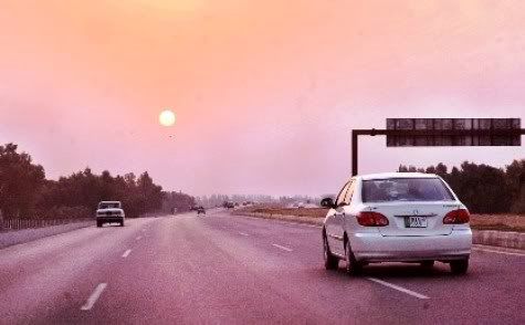
Sunset Over M1
Following photo was taken on October 4, 2008 and is courtesy of Anjum Riaz at APP. It shows sunset on M1.
Related ATP Posts:
1. Traveling on the N5: Part I
2. Traveling on the N5: Part II
3. Traveling on the N5: Part III


Thanks to the National Highway System, it is now possible to travel from Lahore to Peshawar without seeing anything. From this motoroway, Punjab to Peshawar is all steel guardrails and plastic signs, and every place looks and feels and sounds and smells like every other place, and no life is allowed near motoway, its against the law.
Glad to see another phase of Motorway getting completed.
I travell alot in UK and Pakistan’s Motorways are as good as Britian’s.
It took britian 25 years to complete its motorways and it is smaller country then pakistan, Pakistan has come so far 14 years with delays due to Benazir and Nawaz governemnt’s policies and foreign investors/contractors running away but PML-Q has made this dream come true by making it a priority.
The only difference is now Britian charges
Yes, my long long wait to commute through M1 is now over and it saves me at least 30 minutes to go to Mardan from Islamabad. It is a great feeling driving on the motorway along the breath taking landscape where there are brick factories, mountain ridges, katchi abadis and the lonesome trees nailing the vast terrains of uncultivated lands.
Good news. It is also important to develop railroad links for trade and commerce. These highways are sufficient only for limited heavy loading. For example, the NLC trucks created deep and dangerous tire tracks on GT road past Attock…
I can’t helped to notice but Quetta is left out in this Motorway scheme. Can anyone explain it why is that?