Adil Najam
It is difficult, even for Pakistanis, to fully comprehend the scale and size of Pakistan’s great flood. We can all imagine what a home, a locality, maybe even a city, looks like when submerged. But it is difficult for most people – especially those outside Pakistan – to imagine just how great is the ‘great’ in Pakistan’s great flood. Here are some pictures – created from the BBC’s Dimensions website – that might help you comprehend the incomprehensible.


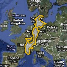
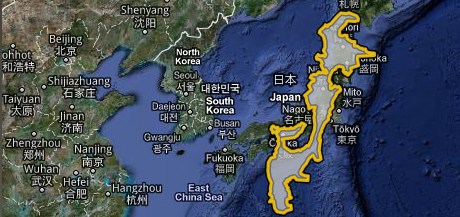
The first map is of the United States and shows that the area of Pakistan’s 2010 floods would stretch nearly the entire United States from upstate Florida to the Canadian border with upstate New York. The next two maps place the area affected by the Pakistan’s floods on the map of mainland Europe – From Denmark down to Spain. The final map overlays the same on a map of Japan.
The maps speak for themselves. As do the numbers.
What can I add to this that I have not already?


Thanks for sharing. I read many of your blog posts, cool, your blog is very good.
Your point of view caught my eye and was very interesting. Thanks. I have a question for you.
Indeed, these floods have changed Pakistan!!
These floods will change the future of Pakistan
Great idea with the pictures. Could someone give a breakup of how much area and what percentage of area in each province is affected?